A nasty winter storm that has left hundreds of thousands in the Southeast and Mid-Atlantic will roar up the East Coast spreading heavy snow inland and a mix or snow and rain at the coast. Southeastern New England will be spared the brunt of the snow as the storm tracks relatively close to the coast. A period of snow will give way to mixed precipitation and rain in most of RI and SE MA on Thursday. Rain could be heavy at times in the afternoon. The storm will also feature strong winds near the coast. Interior Southern New England will see an extended period of snow and mixed precipitation. Snow totals will ramp up quickly from south to north, with the highest elevations of Massachusetts getting the most snow.
Timeline
Snow will or mixed precipitation will begin between 5-8 am in RI and SE MA. The snow may be moderate to heavy for a brief time in the coastal plain before changing to rain from south to north. The change to rain will likely happen between 9-11 am near the coast of RI and in SE MA, and between 10am-12pm in the Providence area. Far western and northwest RI may see the snow hang on until early in the afternoon. The highest terrain of NW RI and southern Worcester County will see a battle between mixed precipitation and snow through the afternoon.
Rain will be heavy at times in most of RI and SE MA through the afternoon. More than an inch of rain is possible, and ice-clogged storm drains could lead to street flooding. The rain will become lighter during the evening before possibly changing back to mixed precipitation or snow late at night. Any snow or mixed precipitation will end between 7-9 am on Friday.
The temperature will rise into the mid to upper 30s on Thursday afternoon, then gradually fall back into the low 30s by dawn Friday. Peak wind gusts over 50 mph are possible in Eastern Massachusetts. The coast of RI and near Buzzards Bay should see gusts to around 40 mph. Inland locations will gust to 30-35 mph.
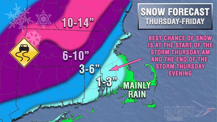
Totals
It is a very close call between heavy snow and heavy mixed precipitation or rain in NW RI. The highest elevations could pick up 6-10″ of wet, heavy snow, but most areas north and west of I-295 will see 3-6″. The coast to the Providence area will likely see 1-3″ of snow from the storm. The immediate coast of SE MA plus Cape Cod and the islands will likely see less than an inch.

Extended Forecast
Friday looks partly cloudy in the afternoon and evening. Highs will be in the mid to upper 30s on Friday. The wind will be gusty during the day and relax at night.
A developing storm may clip Southern New England with light snow or snow showers on Saturday. Highs will be in the low 30s. Right now, it does not look like there will be any accumulation, but it bears watching because if the storm develops closer to the coast it could bring a burst of steady snow.
Quiet and cold weather is in the forecast for Sunday and Monday.


