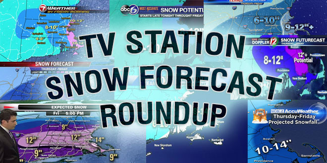
It will be a very close call between a full-fledged blizzard and a moderate snowstorm in Eastern Massachusetts on Saturday evening. A fast-developing storm near the Mid-Atlantic coast will pass by Nantucket Saturday night, bringing a period of snow and strong winds to Southern New England. Here is a look at how the television stations in Providence, Boston, and Hartford are handling the snow forecast.
Certainly subject to change but here's my current thinking. Have a safe weekend everyone. pic.twitter.com/ieAufeOgPP
— Mark Searles (@NBC10_Mark) February 15, 2014
Fast hitting snow storm tonight. Lasts about 6hrs from 6pm till midnight. Travel will be dangerous after sunset. pic.twitter.com/XwpUjwuWkd
— Mike Wankum (@MetMikeWCVB) February 15, 2014
My motto, keep it simple.
Example 1"-3" is 2"
3"-5" is 4, 6"-10" is 8
Here is Sthrn New England Simple Map pic.twitter.com/v6GnJ527Mr— Tim Kelley (@SurfSkiWeather) February 15, 2014
Rain/mix to start Boston to Cape…snow frenzy hits after 6pm. pic.twitter.com/aKQK8JETV0
— Pete Bouchard (@PeteNBCBoston) February 15, 2014
https://twitter.com/RachelFrankCT/status/434544181306871808


