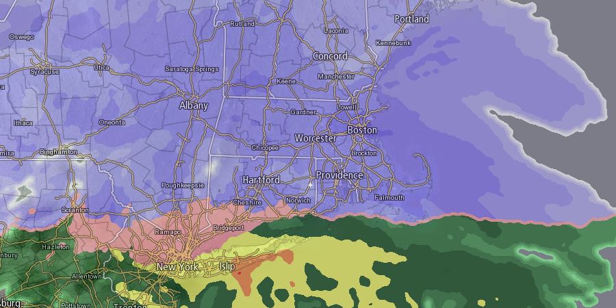
A messy winter storm is heading for Southeastern New England late Sunday night through Monday. Unfortunately, the worst weather will likely coincide with the Monday morning commute. Several inches of snow area likely for most of the area before a change to sleet and freezing rain during the morning. The precipitation will likely change back to snow before ending Monday evening, but most of the snow accumulation will happen before the change to sleet and freezing rain.
The temperature will fall into the teens with increasing clouds Sunday evening. Snow will develop from west to east between 12-2 am in RI and SE MA. Snow will become steady before dawn, and a couple of inches may accumulate by sunrise. Moderate to heavy snow is possible during the morning commute with the temperature rising into the mid to upper 20s near the coast by 8am. A change to sleet and freezing rain is likely from the coast to the Providence area between 8am-11am. It may change to plain rain near the coast as the temperature rises above freezing late in the morning. Snow or sleet is likely in Northern RI through midday.

One of the forecast concerns is the possibility of a few hours of freezing rain inland around midday on Monday. If cold air is locked in near the surface, there could be some glaze on top of the snow that leads to icy travel and possibly a few downed trees and power lines. The best chance of this happening is north and west of I-95 and I-295 in Rhode Island. It’s a situation we will be watching closely on Monday.
Any rain or mixed precipitation will change back to snow in the mid to late afternoon, but the snow will not be nearly as heavy as it was earlier in the day. The snow will end in the mid to late evening. The temperature will fall through the 20s into the teens by midnight, and it will plummet to near 0 inland, and the single digits to near 10 from Providence to the coast.
It will be breezy to windy near the coast, but damaging winds are not expected. Peak gusts of 30-40 mph are possible at the coast, Cape Cod, and islands. The wind will stay gusty Tuesday night as the storm pulls away.
Quiet and cold weather is likely Tuesday. Highs may not reach 20° – even with sunshine. Clouds will increase in the midweek, and a few snow showers are possible on Wednesday. It does not look like a big deal. Another storm is possible late Thursday. Right now, it looks like it will develop far enough east that Southeastern New England gets just a glancing blow. We’ll keep you posted.
Patriots 30 – Seahawks 13


