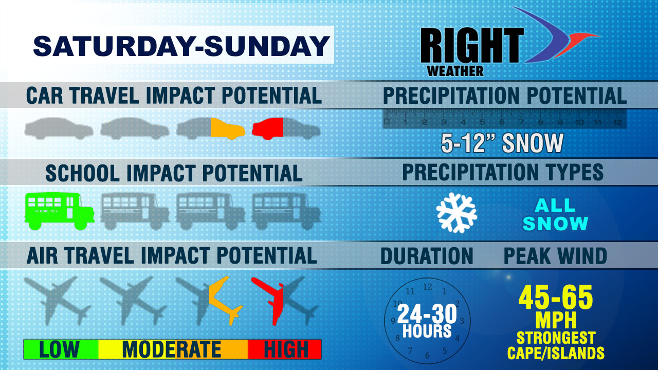
Another moderate to high-impact storm is heading for Southern New England. The start of the storm Saturday afternoon and evening will not be particularly windy, but the second half of the storm Sunday morning will feature howling winds and possibly blizzard conditions – especially in Eastern Massachusetts. The storm will bring plowable snow to all of Southern New England, with the highest totals likely in Eastern Massachusetts. Here are some of the ways the storm will impact everyday life.

CAR TRAVEL IMPACT POTENTIAL
Travel will be slowed by snowy roads from late Saturday afternoon through midday Sunday. If you’re comfortable driving on snow-covered roads, then I would not cancel the Valentine’s Day dinner reservations. It is likely to be slow-going, but manageable Saturday evening. The worst car travel will be Sunday morning with strong winds and moderate to heavy snow bands spinning through. Visibility will be severely limited most or all the morning. Roads will be snow-covered. The snow will end early in the afternoon, but travel will be affected through the day with gusty winds blowing snow back onto frigid roads.
SCHOOL IMPACT POTENTIAL
The storm is hitting on a weekend, for a change. Most school districts are on February break next week, and those that are not will have the Monday holiday to recover from the storm.
AIR TRAVEL IMPACT POTENTIAL
Even though it will be snowing Saturday evening, there should be some air traffic into and out of Southern New England airports. The real trouble is Sunday when the strong winds and near-blizzard conditions hit in the morning. Winds will howl through the day, and Logan will likely be in worse shape than TF Green.
SNOW TOTALS
Most in RI will see 5-9″ of snow, with the lowest totals likely in the southwest corner of the state. There will be 8-12″ of snow from E RI through all E MA. IF there is no lull Saturday night, some spots in E MA may reach nearly a foot and a half of snow. It will not be the biggest snow storm of the season, but it’s no slouch, either.
PRECIPITATION TYPE
All snow with this one. A wealth of cold air, and likely a “fluff factor” to the snow that allows for higher snow totals with a light and fluffy snow.
DURATION
It will start Saturday afternoon and snow will end early to mid afternoon on Sunday. A 24-30 hour headache.
PEAK WIND
The wind will be strong enough to cause some damage in Southeastern New England. It will likely not be widespread, but isolated power outages are possible with peak gusts near 65 mph in Eastern Massachusetts, and closer to 50 mph in Rhode Islands.


