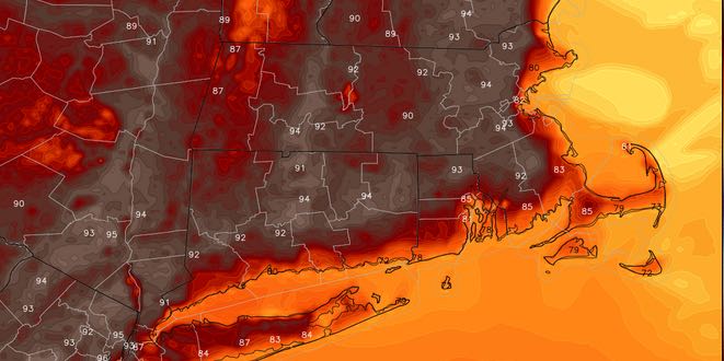
Hot and Humid Start to the Week

Inland Southeastern New England is well on the way to a heat wave. The high temperatures in Boston and Providence over the weekend were in the low 90s. There is a high likelihood that it will reach 90 for a third straight day on Monday.
MONDAY
It will be hazy, hot, and humid on Monday. Highs will be 90-95° away from the coast, and in the mid to upper 80s near the coast with an onshore breeze developing around midday. Monday night looks mainly clear with patchy fog developing. Lows will be near 70.
TUESDAY
The high temperature may reach 90 again on Tuesday. It will be a warm start to the day, and any low clouds and fog will burn off by mid-morning. There is a 10-20% chance of a pop-up thunderstorm in the afternoon. Highs will be near 90 inland, and in the 80s at the coast with an onshore breeze. Tuesday night will be warm and humid. Lows will be in the low 70s.
WEDNESDAY
It looks warm and muggy, but not as hot as the weather early in the week. A southerly wind will keep the temperature between 85-90 inland, and in the low to mid 80s near the coast. Skies will be partly to mostly sunny. It will still be humid, and lows will be near 70.
THURSDAY
Look for partly cloudy skies with highs in the low to mid 80s. There will be a south to southeast breeze and high humidity.
FRIDAY INTO NEXT WEEKEND
A slow-moving disturbance brings the chance of showers and thunderstorms Friday into next weekend. The best chance of rain on Friday is in the afternoon and evening. It will be mostly cloudy, breezy, and humid, with highs in the upper 70s to low 80s. Saturday and Sunday both looks partly to mostly cloudy with scattered showers and thunderstorms. There is a better chance of rain on Saturday. Highs will be in the 70s to low 80s.


