A strong and moisture-laden storm system brings a heavy rain threat to parts of Southern New England on Tuesday. Localized street flooding is possible in the hardest hit areas.
TUESDAY
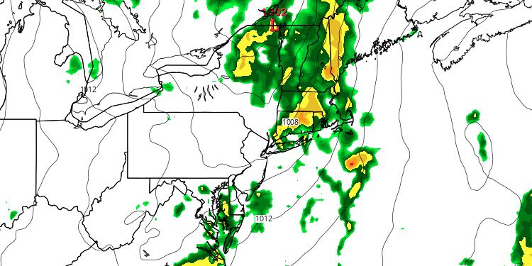
The day will begin with mostly cloudy skies. It will be muggy and mild, with temperatures in the mid to upper 60s. The threat of rain increases by mid to late morning, with showers and thunderstorms likely during the afternoon. The main threat from the thunderstorms is for locally heavy rain that may lead to poor-drainage flooding. Most areas should see around a half-inch of rain, but the hardest hit may receive 2″ or more in heavy thunderstorms. The temperature will be in the low 70s during the afternoon with a southerly wind.

TUESDAY NIGHT
The threat of rain continues Tuesday evening, ending before dawn on Wednesday. Lows will be in the mid 60s Tuesday night.
WEDNESDAY
It will turn less humid as the sun returns on Wednesday. Highs will be in the low to mid 80s with partly cloudy skies. An isolated inland afternoon shower cannot be ruled out. There will be a west-southwest breeze. Wednesday night looks mainly clear and comfortable. Lows will be in the low to mid 60s.
Don’t forget to check out the Perseid meteor shower. It peaks Wednesday and Thursday nights. 60-100 meteors per hour are possible. The best viewing is between 12am-4am away from city lights. Look to the northeast.
THURSDAY
It looks like a nice day with highs in the low 80s under partly to mostly sunny skies. It will not be humid. The temperature will dip to near 60 by dawn on Friday under clear skies.
FRIDAY
The workweek will end with nice, warm weather on Friday. It will be mostly sunny, and the temperature will reach the low to mid 80s after the cool start. Once again, it will not be too humid. The humidity will increase Friday night as a weak storm system approaches from the west.
WEEKEND
Saturday looks warm and muggy, with a southwest breeze. Scattered showers and thunderstorms are possible in the afternoon and evening as a cold front eases into Southeastern New England. Highs will be in the mid 80s inland, and near 80 at the coast. The breeze will pick up to 10-20 mph. It will be mild and muggy Saturday night. Sunday may begin with clouds before sunshine increases and the temperature reaches the low to mid 80s. It will likely be very warm and muggy early next week.


