The temperature will not be straying to far from normal in the next week. The one temperature spike will come in the middle of the week as a wet weather system brings much-needed rain late Wednesday into early Thursday.
TUESDAY
It will stay mainly clear on Tuesday. After a cold start in the 30s, the temperature will rise into the mid to upper 50s under mostly sunny afternoon skies. It will be a pleasant day. Clouds will increase Tuesday night. Lows will be in the low to mid 40s.
WEDNESDAY
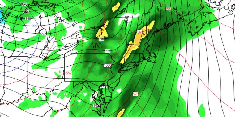
Clouds will continue to thicken during the day on Wednesday. A few showers are possible by midday, and steadier rain may develop by late in the day, especially in SW RI. Highs will be in the 60s. It will stay mild with rain likely Wednesday night. The wind will likely gust over 30 mph late Wednesday night, especially near the coast. The temperature will stay in the 60s overnight.

THURSDAY
Rain ends early Thursday, and it will stay mild throughout the day. Highs may reach the low 70s with enough sunshine. A cold front will move through Thursday night, but the air behind it will not be too chilly. Lows will be in the 40s Friday morning.
FRIDAY
Look for a dry and pleasant day on Friday. It will be breezy in the morning and less so in the afternoon. Highs will be in the mid to upper 50s. Friday night looks clear and seasonably cool. Lows will be in the upper 30s to low 40s.
WEEKEND
Saturday should be a decent day with highs in the mid to upper 50s under mostly sunny skies. There will not be much of a breeze. The weather looks nice for trick or treating as the temperature settles back into the 40s by mid to late evening. Sunday will be dry and milder with a southwest breeze. Highs will be in the low 60s on Sunday.


