December 2015 is on track to be the warmest on record by a wide margin in Southern New England. Some of the warmest weather, relative to normal, will arrive Christmas Eve and last through Christmas Day.
WEDNESDAY
The day will begin with a glimmer of sunshine before clouds quickly increase on a damp southeast breeze. Rain will develop by late in the day, and it looks steady at night. The temperature will rise from the upper 40s early in the day to the mid 50s by late in the day, and it may reach the low 60s by midnight. Rain will likely end by early Thursday morning.
THURSDAY
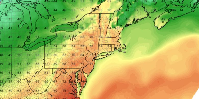
It will be a cloudy, damp, and near-record warm day. Highs will be in the low to mid 60s, challenging the 64° record high temperature set just last year. It will stay balmy at night, with a passing shower possible, and the temperature falling into the mid to upper 50s by Christmas morning.
CHRISTMAS
Look for clouds to some sunshine on Christmas day. Highs will be in the low 60s. The record high for the date, set just last year (63°), will be challenged. Clouds will thicken by late in the day, and rain may return in the evening. It will turn a bit cooler at night with lows in the 40s Saturday morning.
SATURDAY
Saturday will be mostly cloudy and cooler, with highs in the 40s and a northeast breeze. More rain is possible Saturday night as a warm front lifts north through the region. The temperature may climb into the 50s Saturday night with patchy dense fog.
SUNDAY
Unseasonable warm returns on Sunday with highs flirting with 60° again under mostly cloudy skies. A few more showers may move through as a cold front passes Sunday evening.
MONDAY
Right now, Monday looks like the rare cool day, with highs in the 30s under partly sunny skies. How will we survive it!?


