After a few days of cold weather, it will all retreat as the next storm system approaches this weekend. Once again, we’ll see much more rain than snow in Southern New England. It’s the story of the winter so far, but that was the case last year through mid-January, too. Are we going to see a huge pattern flip like we saw in early 2015? Most likely not, but it should get more wintry than the paltry snow threats we’ve had so far this winter.
A weak system could bring a bit of light snow Sunday night into Monday morning. It will not be a huge deal, with an inch or two of accumulation possible in a worst-case scenario. Most of next workweek will be cold and dry, with the coldest and windy weather likely Monday through Tuesday. Highs will only be in the 20s.
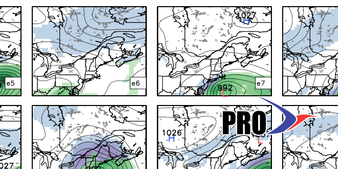
The setup is decent for a storm next weekend. It’s a long way out, but as you can see in the video, the computer model ensembles are in decent agreement. It’s way too early to say how big of an impact it would have, what the precipitation type would be, etc. Just keep it in the back of your mind that there could be a storm Sat-Sun.
Looking farther down the road, the weather does not look extremely cold to end January and begin February. The southern branch of the jet stream stays active, but that hasn’t yield much snow so far this season. Unless the storm track gets locked in just offshore, this may end up being a more of a winter to forget than remember for snow-lovers.


