Snow and rain Monday will have it feeling more like late February than early April in Southeastern New England. A chill will stick around for most of the week, with milder weather only arriving with a rainstorm late in the workweek.
MONDAY
Snow is likely inland. Snow may mix with or change to rain near the coast. The high April sun angle should prevent the snow from sticking well to pavement during the day. 2-4″ may accumulate mainly on the grass inland. There will be an inch or less south of Providence. Highs will be in the 30s. Icy spots will develop overnight as the snow ends by midnight and the temperature falls into the mid 20s by dawn.
TUESDAY
Watch out for icy patches early in the day. Partly sunny, very cool for early April. Breezy. Highs only near 40.
WEDNESDAY
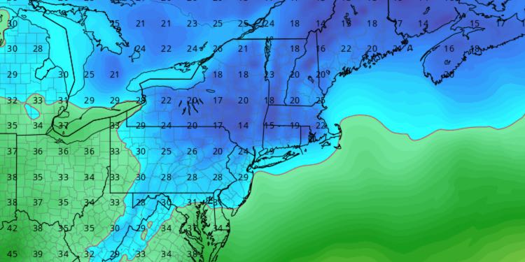
Clear and very cold early in the day. Near-record lows in the teens and low 20s. Sun and clouds, not much warmer in the afternoon. Highs in the low 40s.

THURSDAY
A strong storm system approaches from the west. Clouds thicken, rain develops around midday and continues into the night. Windy and milder, with temperatures in the 50s during the rain. Steady rain moves out by dawn on Friday.
FRIDAY
Cloudy, another storm may form and bring chilly rain showers (and possibly wet snow inland) late in the day and at night. Highs in the 50s, turning colder at night.
WEEKEND
The weekend looks mainly or all dry, but unseasonably cool. Highs will be in the mid 40s with clouds giving way to some sun on Saturday. It will be partly cloudy with highs in the low 40s on Sunday. Normal highs are in the mid 50s.


