April is off to a rough start with snow on two of the first three days of the month.Monday’s storm led to some headaches for travelers as roads were a little slick early in the day. It will be relatively cold through the midweek, even as sunshine returns on Tuesday. As soon as the wind shifts to the south and warmer weather returns, there will be a storm system bringing rain Thursday afternoon and night.
A deep dip in the jet stream (trough) will move into the Northeast after the storm on Friday, and the weekend will either be very cool and dry or another storm (or two) developing near the base of the trough will come close enough to bring rain and possibly mixed precipitation. Right now, we’re leaning towards the dry/cool scenario, which is the lesser of two evils, I guess. The temperature will be running 10-15° below normal this weekend.
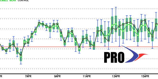
The pattern looks unsettled and somewhat cool next week, too. More rain is possible in the midweek, and there could be another storm bringing rain into next weekend. Overall, there is not a heck of a lot to look forward to through mid-April. It looks like the best chance of seeing near or above normal temperatures is not with sunshine, but with the rain events and a southerly wind. Precipitation is likely to be well above normal through mid-month, and the temperature will be near or below normal. Really, the only chance of near normal is if the storm track is to our west and brings in mild air that stays for 1-2 days. If the storm track shifts and we don’t get the warmer southerly winds with the rain, then it will average well below normal through the middle of April.


