A warm start to the workweek will not last as gradually cooler weather descends on Southeastern New England during the week. By late in the workweek it will be a bit cool for mid June, with highs struggling to reach 70, and lows in the 40s to low 50s. Dry weather is likely late in the workweek, but we’re watching the potential for more rain this weekend.
MONDAY
Plenty of sunshine. Warm, and a bit humid, but not oppressive. Highs in the low to mid 80s inland, and near 80 at the coast. Partly cloudy, mild at night. Lows in the low 60s.
TUESDAY
Sun gives way to partly cloudy skies. Pop-up afternoon and evening showers/storms are possible, but most should stay dry. Highs near 80.
WEDNESDAY
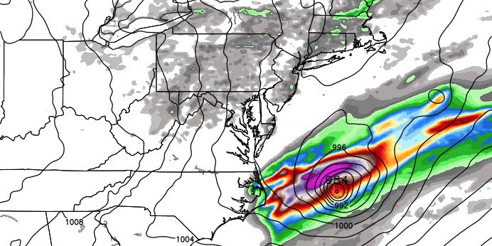
Tropical Storm Colin passes harmlessly out to sea well southeast of Nantucket. Partly to mostly cloudy by late in the day. Scattered showers and thunderstorms. Cooler with highs in the low to mid 70s.
THURSDAY
Partly cloudy, a gusty northwest breeze. Cool with highs in the mid 60s to near 70. Clear and cool at night, lows in the mid 40s to low 50s.
FRIDAY
Partly to mostly sunny. Highs in the low 70s. Cool again at night with lows in the 40s to low 50s.
WEEKEND
A storm system moving through the Great Lakes is likely to bring at least some showers at some point this weekend. The early outlook is for the best chance of rain from late Saturday into Sunday. Highs will be in the 70s with increasing clouds on Saturday. It’s unclear how quickly and where the storm will redevelop near the coast on Sunday. In a worst-case scenario, it’s cool and rainy. If the storm does not develop quickly or near Southeastern New England, then it may be a mainly dry and seasonably cool day.


