An extended stretch of very warm and muggy weather is ahead for this week. The heat and humidity may break heading into the weekend, but showers and t-storms are likely Friday night and Saturday, with showers possible again on Sunday.
TUESDAY
Early clouds then becoming partly sunny. Warm and humid. Highs in the low to mid 80s inland, upper 70s to low 80s coast. Clouds may be stubborn near the coast. Tuesday night looks mainly clear and mild, with lows in the 60s.
WEDNESDAY
Any early fog and mist burns off to mostly sunny skies. Hot and humid inland, very warm and muggy near the coast. Highs in the low to mid 90s inland, mid to upper 80s at the coast.
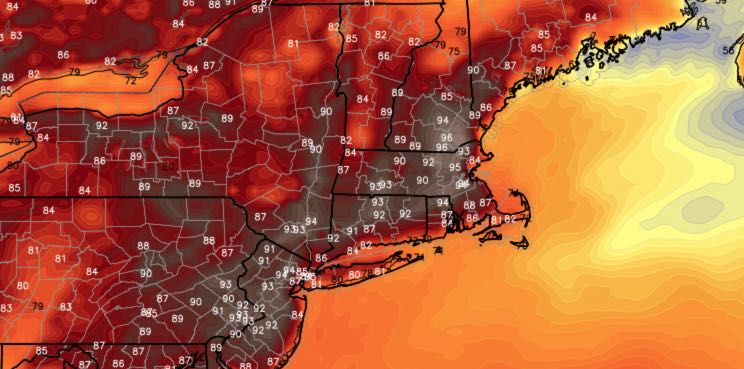
THURSDAY
Another hot day. Hazy, hot, humid, with highs in the low 90s inland, and 80s at the coast. Lows will not be far from 70 Thursday night.
FRIDAY
Hazy, very warm to hot. Humid. Scattered afternoon thunderstorms are possible. Highs in the upper 80s to low 90s inland, 80s at the coast. Showers and t-storms at night – especially inland.
SATURDAY
Mostly cloudy, showers and t-storms possible through the day. Highs in the 70s to low 80s. Still quite humid.
SUNDAY
Sun and clouds, pop-up afternoon showers and t-storms. Highs in the low 80s.


