This incredible stretch of unseasonably cold weather continues with a blow from a mega-storm on Thursday. That’s followed by record-breaking cold this weekend. The storm has the potential to cause power outages, and that could lead to a disaster of burst pipes if it is not restored before the mother lode of cold arrives Friday into Saturday. Even more concerning is the thought of anyone without heat having to ride out the frigid stretch from Friday into Sunday. The temperature may not make it out of the single digits on Saturday, and it will be below zero Saturday night.
First things first, enjoy the relative warmth on Wednesday! It may actually get to 30° in spots during the afternoon. While it’s quiet in New England, a massive storm system will be developing off the Southeastern US coast. The storm will become incredibly intense by early Thursday as it heads north along the Gulf Stream off the Eastern Seaboard. While the center of the storm will not be as close to the coast as some earlier blizzards, this large and super-intense storm has the potential to produce blizzard conditions in all of RI and SE MA.
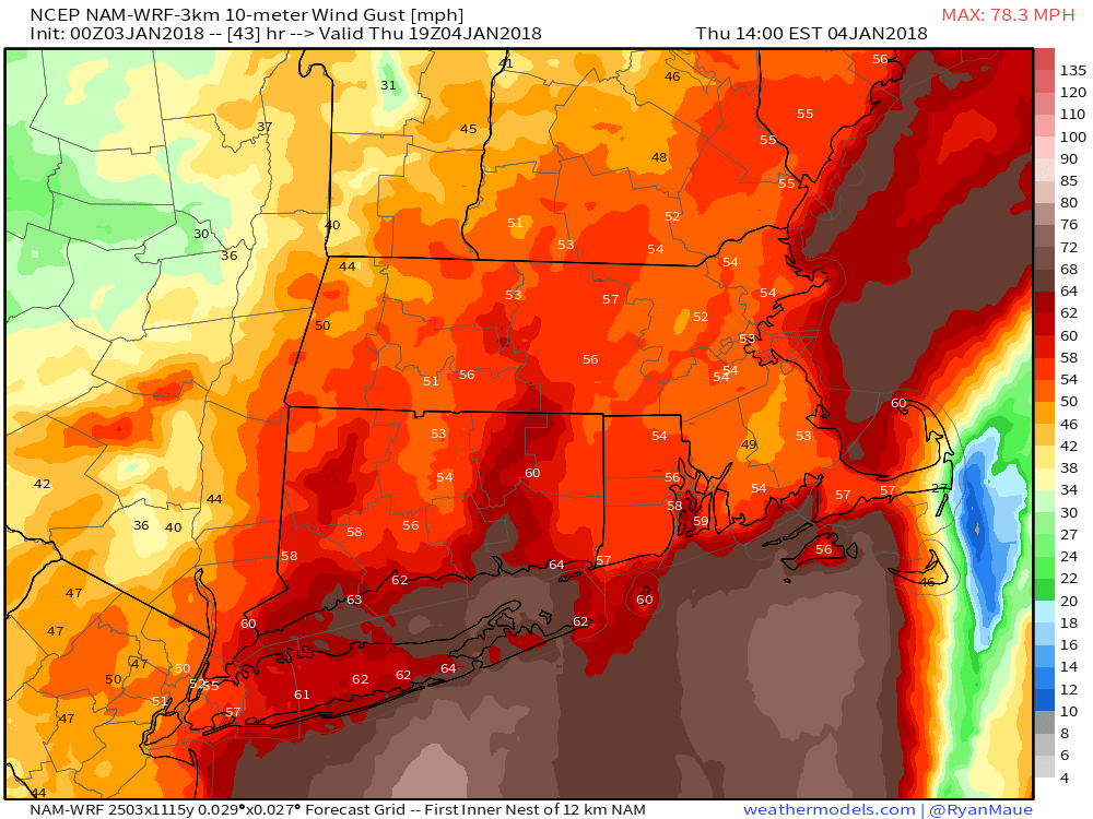
Expect snow to develop between 4-7 am on Thursday. The snow will be heavy at times from dawn through the mid-afternoon before quickly winding down in the evening. Winds will gust over 40 mph and may reach 50-60 mph in all of RI, especially near the coast. Gusts over 60 mph are likely on Cape Cod and the Islands. I would not be surprised if Nantucket saw 75+ mph gusts from this storm. The combined snow and strong winds may lead to the power outages.
The snow forecast is actually kind of tough on this one, with uncertainty about (1) the amount of precipitation the storm will bring and (2) the snow ratio as warmer air moves in aloft. At this point, it looks like it will not be super dry and fluffy snow. I expect about a 10:1 or 12:1 snow-liquid ratio, and that means more than a foot will likely fall in parts of RI and SE MA. It’s not a very long storm, so isolated totals over 20″ are unlikely, but not impossible. See the snow odds below for the Providence area to give you an idea of the uncertainty.
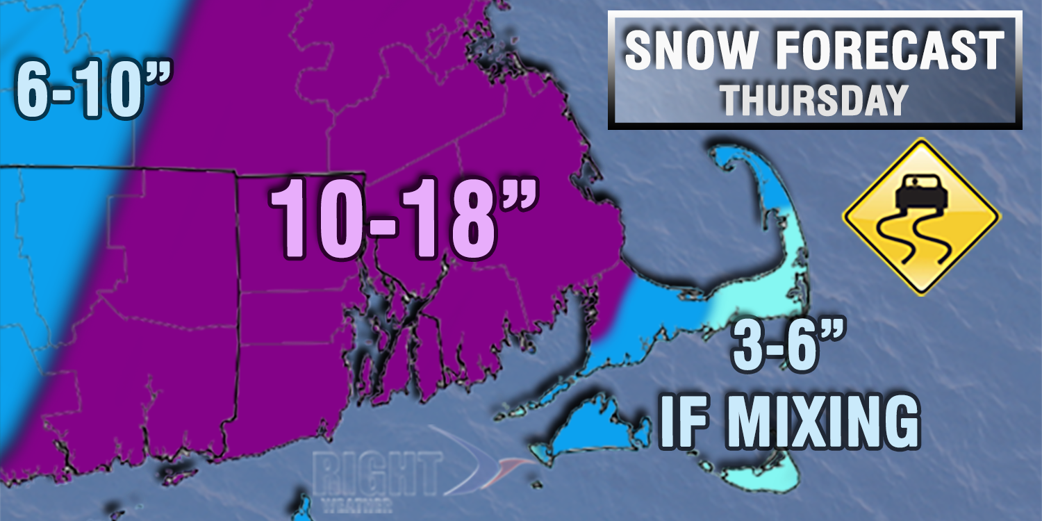
Less than 3″ – 5%
3-6″ – 15%
6-10″ – 25%
10-16″ – 40%
16″+ – 15%
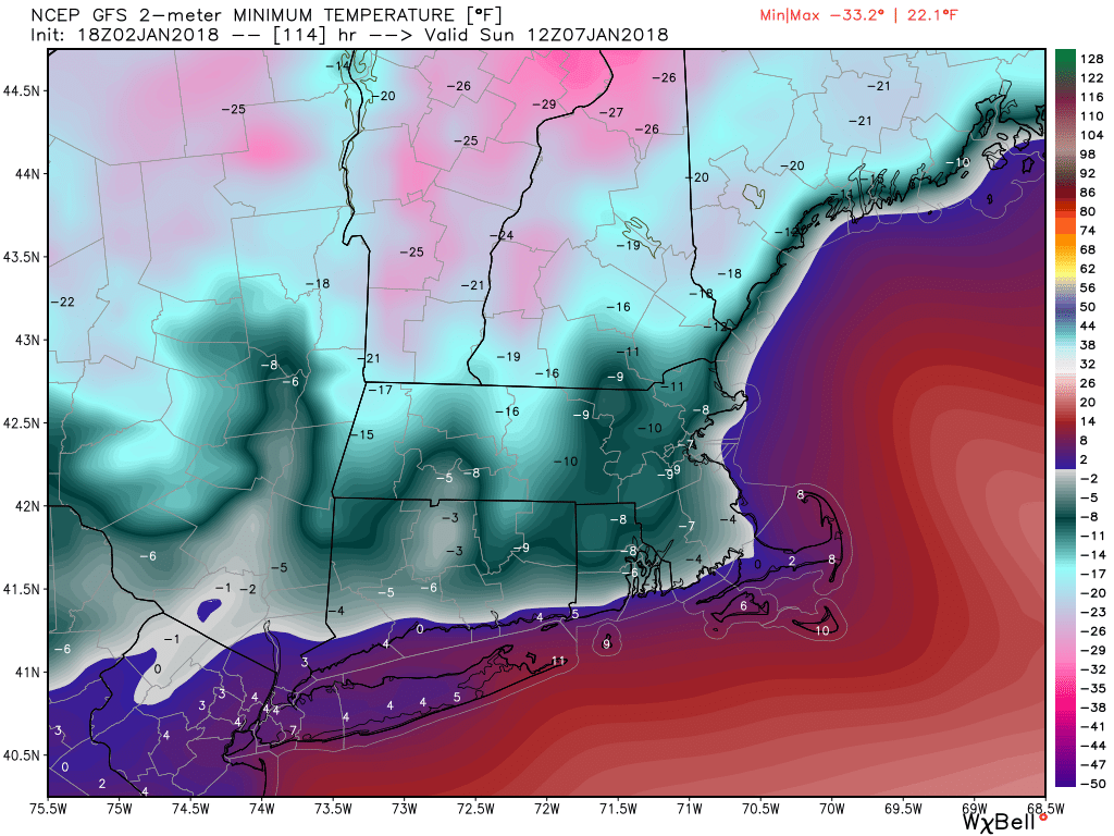
The weather after the storm is nothing short of remarkable. The temperature will hover in the low teens through midday Friday before falling to near or below zero by midnight. It will be below zero in many spots Saturday morning, and in the single digits in the afternoon. Record-breaking cold well below zero is likely Saturday night. Northern RI may be colder than -10, and it will likely fall below zero all the way to the coast. The temperature rebounds to the teens on Sunday afternoon. We’ll finally get a bit of a thaw early next week.