Category 4 Hurricane Michael is bearing down on the Florida Panhandle today. The storm is expected to make landfall this afternoon with maximum sustained winds 140-145 mph – an extremely dangerous storm. The storm’s eye will be near Panama City. A storm surge up to 13′ is possible, along with the devastating wind gusts, and 4-8″ of rain.

Michael will continue moving northeast over the next couple of days, and is expected to pass south of New England on Friday. The storm will be steered out to sea by a cold front, and the interaction between the cold front and tropical system will bring showers and thunderstorms to Southern New England. After weakening to a tropical storm over the Southeastern United States, the storm may become a hurricane again over the Atlantic Ocean. Strong wind will likely not be a factor anywhere in New England as the storm passes by. The best chance of heavy downpours is over the southern part of RI, Cape Cod, and islands late Thursday night into Friday morning. It’s unclear exactly how the cold front will interact with the storm, and there is no guarantee of torrential downpours.

While the storm is hitting Florida today, the weather will be unseasonably warm and muggy in Southern New England. High temperatures will range from the mid 70s coast to low-mid 80s inland with dew points well into the 60s under partly cloudy skies. Mist and fog develop tonight with lows not far from 70° early Thursday.
Expect unsettled weather on Thursday. Scattered showers and thunderstorms are possible during the day in Connecticut, and primarily in the afternoon in Rhode Island and Southeastern Massachusetts. The shower/storm threat continues Thursday night into early Friday – shifting east into Cape Cod and the islands by midday Friday. High temperatures will be in the 70s on Thursday, and then fall into the upper 50s to low 60s on Friday. There is a decent chance that Friday afternoon is mainly dry with mostly cloudy skies and cool temps.
Speaking of cool temperatures, the weekend will start out quite chilly with temps in the low-mid 40s Saturday morning, and likely not getting much above 50° Saturday afternoon. Expect a lot of clouds, and there may be a few showers around on Saturday as a disturbance passes through. It will clear out with chilly conditions Saturday night. The first game of the ALCS at Fenway park will feature temps in the 40s, and there could be a few towns that reach the 30s by dawn on Sunday.
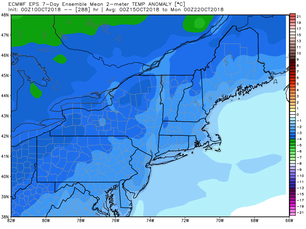
Blue=chilly – a cool pattern for a change mid to late next week
I expect the temperature to rebound into the upper 50s to low 60s with dry skies Sunday afternoon. It will cool into the 40s again Sunday night, and bounce into the 60s on Monday. The early outlook for the middle to end of next workweek is for another cool-down with highs in the 50s from Tuesday through the end of the week. After Thursday/Friday, the next best chance of steady rain is late Monday into early Tuesday.


