Brace yourself for a chilly stretch of weather for the rest of this month into November. It’s been a while since we have seen a consistently cool pattern in Southern New England, and that will make this cool snap feel even colder since the first half of October was among the warmest on record.

The heat may click on as soon as Thursday night as cold air settles in
The first frost/freeze is possible all the way to the coast either Friday or early next week. There is a very good chance of sub-freezing weather inland on Friday morning or Monday morning. The pattern looks mainly dry through the weekend. The best chances of precipitation in the next week are scattered rain showers Wednesday late-afternoon and evening, and again on Saturday as another cold front passes.
The two coldest days in the next week will likely be Thursday and Monday. Highs may not reach 50 either of those days, and the low temperature will be in the 30s. The “warmest” days will likely be Wednesday and Saturday with highs near 60. Showers are possible on Saturday, and clouds will thicken Wednesday afternoon.

Most of the Eastern US feels the chill in the next 7 days
I have mentioned in prior posts and videos, and I’ll say it again – I think that we need to watch for a storm along the Eastern Seaboard in the last 8-10 days of the month. The pattern is ripe for a slow-moving wind/rain storm. If it all came together just right, there could be some inland snow. I am looking at a weather pattern and seeing the potential for a storm to develop. It’s possible that it never comes to fruition, but I think it’s something to keep an eye on.

Models (and pattern) hinting at a potential coastal storm sometime next week
As far as November goes, it does not look like there will be a big warm-up coming anytime soon. Of course the highs/lows by early November are 50s/30s, so even “seasonable” days have a chill. I expect the temperature to stay near or below normal into the first half of next month. A negative North Atlantic Oscillation keeps the chill more or less locked in, and that’s a pattern to watch for slow-moving storms. A negative NAO almost always favors cool weather at this time of the year.
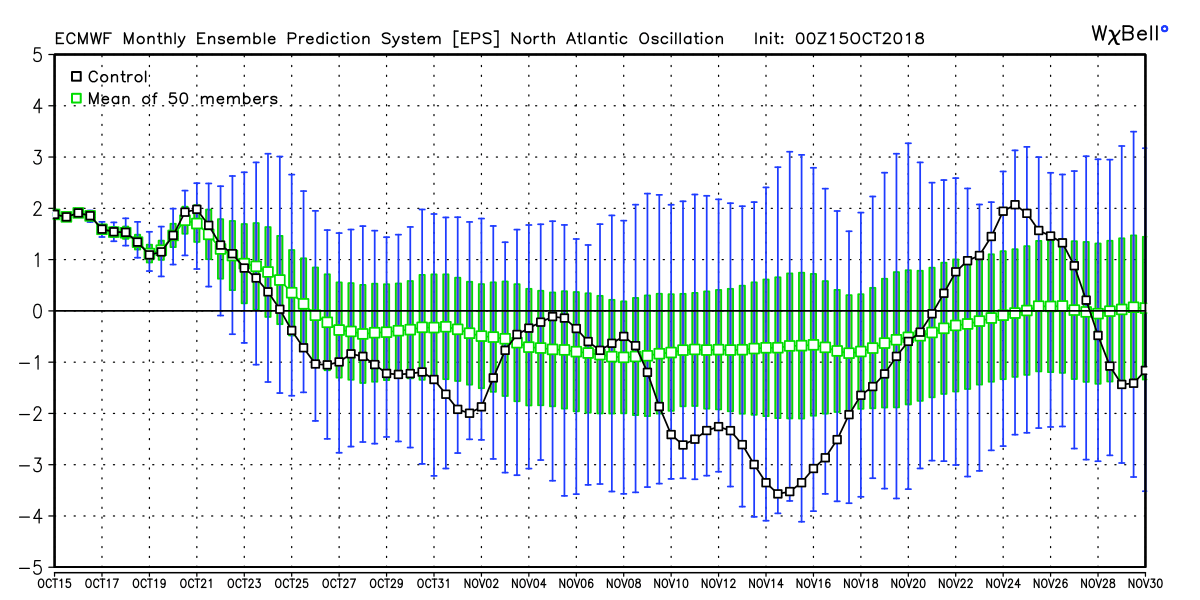
EPS weeklies showing a negative NAO into November – expect it to stay cool or close to normal through Nov 15
Later this month I’ll be checking the Siberian Snow Advance Index to see how much snow is falling in the northern hemisphere high latitudes. That can be an indicator to what type of winter we’ll see in the Northeast.


