Chilly air rides in on a gusty northwest wind tonight. Expect the temperature to be near or below freezing at dawn on Wednesday. The wind helps to dry the pavement, but it could be a little slick/icy near wet leaf piles. Watch your step in the morning. It looks like a cold Wednesday with highs generally in the mid to upper 30s under partly cloudy skies. The wind will make it feel like the 20s for most of the day.
The temperature dips into the 20s Wednesday night, and clouds increase by midday Thursday with temps in the 30s again. Snow and sleet develops from southwest to northeast through Southern New England on Thursday. Snow and sleet is likely by sunset in most of Connecticut and between 5-7 pm in Rhode Island and eastern Massachusetts. A change from snow/sleet to all sleet and then rain is likely from south to north Thursday evening. I think that there will be enough sleet involved to help limit snow accumulations on paved surfaces. (Keep in mind, my snow forecasts are for PAVED surfaces – stuff that needs to be shoveled or plowed)
A change from sleet to rain is likely overnight in all of CT, RI, and E MA. Rain continues Friday morning before the storm heads out in the afternoon. The temperature climbs from near freezing at the start of the event to near 40 (especially at the coast) by dawn on Friday to in the low-mid 40s during the day on Friday.
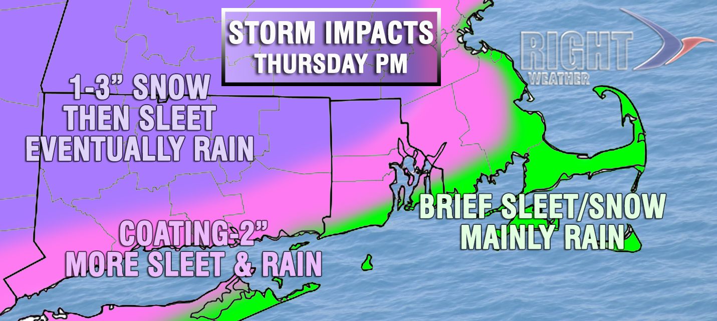
This is most likely a minor event, and there’s a good chance that the ground will be bare of any snow/sleet by dawn on Friday in areas shade in pink/green. It will not get as mild in the purple shaded area, so some residual snow/sleet may still be on the ground early Friday, but I think roads will be fine. The best chance of any slippery travel is between 5-10 pm in CT, and 6-11 pm in RI and E MA – especially away from the coast in all three states.
The weekend looks cool and mainly or all dry. A few flurries or snow showers cannot be ruled out as weak disturbances pass by on Sunday. Highs will be in the 40s on Saturday, but may not get to 40 on Sunday. It stays chilly, but most likely mainly dry through the middle of next week. The early, early outlook for Thanksgiving is for dry weather with temps in the 40s. There may be some precipitation by Black Friday or next Saturday, but that’s a long way down the road!


