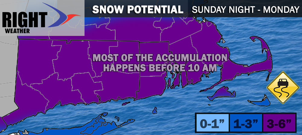
A moderate snow event brings accumulating snow through all of CT, RI, and SE MA Sunday night into Monday morning. It’s not a whopper, but should be enough to slow the commute for anyone who has to work on Presidents’ Day. The steadiest snow is likely between 3-10 am. Snow develops in western CT late in the evening, and between 12-2 am in RI and SE MA.

Most of the accumulating snow happens before 9-10 am, but snow showers and flurries will linger in the afternoon and evening. I updated the snowfall map this morning on the private Facebook group, and it is updated again below to include all of RI, CT, and SE MA in 3-6″ range. I think most towns will be around 4-5″. I only expect a coating-1″ of snow between the afternoon/evening snow showers.
The last of the flurries should move out between 6-9 pm – ending first in western CT and last in SE MA. Expect a cold night with temps falling into the teens to low 20s. Tuesday and Wednesday will be cold with temps struggling to get above freezing during the day.
The next storm system is Wednesday evening into early Thursday. It looks like the old snow to mix to rain event, with a minor snow accumulation possible before the mix/rain. It could be enough to shovel and plow if the cold air hangs on for a few hours Wednesday evening. Milder weather is likely late in the workweek and for the first half of the weekend. Another storm could arrive Saturday night -> Sunday, and right now it looks like more rain than snow/mix.
I’ll have more updates on Monday.


