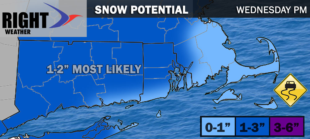
It will be another clear and cold night with the temperature dipping into the teens to low 20s by dawn on Wednesday. Morning sunshine gives way to clouds in the afternoon. Snow may develop in southwestern CT in time for the evening commute around 3-5 pm. The snow spreads northeast reaching Rhode Island and Southeastern Massachusetts between 6-8 pm. Snow may briefly be steady, but it will not last for more than a few hours before mixing with and changing to sleet. This should happen by midnight in most or all of CT, RI and SE MA. Most towns will pick up about an inch of snow, with 2″ possible in higher terrain and in Southwest CT where it will begin first. There’s a lower chance of an inch of snow in Southeastern MA.
A couple of hours of sleet may be followed by freezing rain – especially inland. Above-freezing air will move into the coastal communities shortly after midnight changing any freezing rain and sleet to rain. The sub-freezing air may hang on for a good chunk of the night in northern CT and northwest RI.

The storm will move fairly quickly and should be out of the picture for most of Southern New England by 7-8 am on Thursday. Any towns that are below freezing at 8 am will warm pretty quickly on Thursday morning. By noon it’s in the mid 30s to low 40s, and it will sure into the mid 40s to low 50s during the afternoon with some sunshine.

Quiet and seasonable weather is ahead for Friday and Saturday. Look for highs in the 40s Friday and not too far from 40 on Sunday. Both days should feature some sunshine. Clouds will roll in late Saturday ahead of a storm system that may bring a very brief period of snow/sleet before rain Saturday night. It does not look like a high-impact winter weather event before the rain arrives. I will fine-tune this forecast as the week progresses. Showers linger on Sunday with temps well into the 40s.
It will be dry again early next week. There are some signs of a storm system in the middle of next week as we near the end of February. It’s way to early to speculate about the specifics of the storm, but just a heads up that there could be more wintry weather in the middle of next week.


