The first half of May was wet and cool in Southern New England. It looks like the second half of the month will go in the books as slightly warm and dry. There have been 5 straight 70+ degree days in the Providence area for the first time in 8 months, and although it may not reach 70 on Wednesday or Thursday, it will not be too far from the normal high for this time of the year.
There are some showers to talk about in the next five days, but the rain threatens mainly at night, with dry weather likely most of the time between sunrise and sunset. The first shot at a few showers is in the western half of Connecticut Wednesday night into early Thursday morning. Widespread steady rain is not likely in Connecticut, and it will most likely stay dry in RI and SE MA. There will be some clouds around on Thursday with temperatures in the 60s – a pretty good day for yard work.
Showers are possible in all of Southern New England from around sunset on Thursday until 2-4 am on Friday. There may be some embedded thunderstorms, too. The temperature will dip into the 50s Thursday night. Look for a blend of clouds and sun on Friday with a high temperature in the 60s. It may turn cooler in the afternoon as a disturbance swings down from the north to south. A passing shower cannot be ruled out in eastern CT, RI or SE MA. It looks like a better day west of I-91 in Connecticut.
We have reached that point in the year where many of the shower threats will include possible thunderstorms. As we know, thunderstorms can produce locally heavy rain. It will often be a case of all-or-nothing with rain in the next few months. Some towns could get a quick 1-3″ of rain in a torrential thunderstorm when another town a few miles away gets nothing. Where appropriate, I will try to give rain estimates for any given storm system, but just know that there could be a wide range of rain totals anytime thunderstorms are in the forecast.
Memorial Day Weekend Forecast
The unofficial start of summer features mainly dry weather each of the three days during the holiday weekend. The best bet for rain is Saturday night as a disturbance passes by and opens the door to warmer weather on Sunday. You can expect partly sunny and pleasant conditions on Saturday. It may be in the 40s at dawn, but will warm into the mid 60s to low 70s by midday. Any rain should hold off until after sunset.
Clouds will give way to warm sunshine on Sunday. Highs inland may reach 80, and it will be closer to 70 at the coast. Monday does not look quite as warm, but it still looks good. A sea breeze will keep the coast between 65-70, and inland locations should reach the mid 70s. Expect some afternoon clouds with a slight chance of a shower late in the day.
Late May Outlook
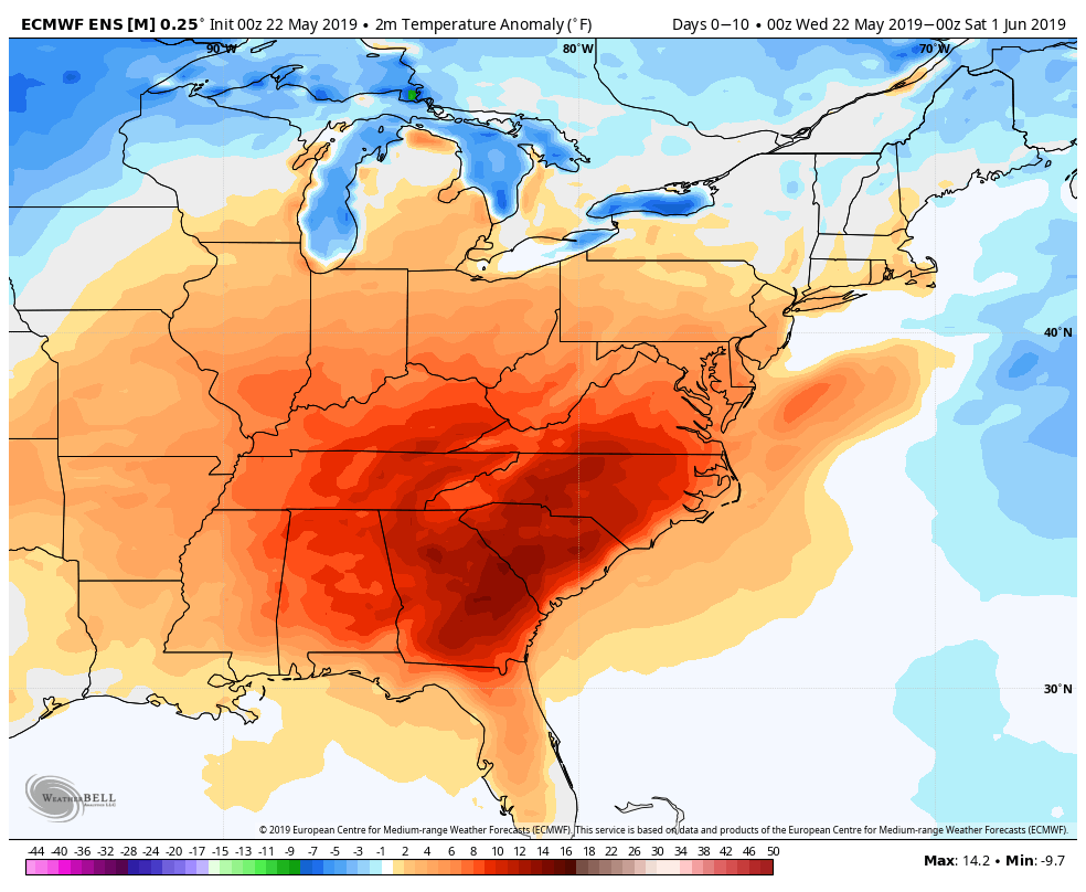
Big-time heat and humidity moves into the Southeastern United States for the last week of May. It’s possible the summer-like warmth will roll into Southern New England next week – at least for a day or two. I wouldn’t be surprised if we saw the first 90 degree day inland before June 1.