Hurricane Dorian absolutely devastated the northern Bahamas islands. The storm crawled at an average of less than 2 miles per hour through Abaco and Grand Bahama island while packing winds between 130-185 mph. The relentless wind, storm surge and tropical rain toppled and inundated houses. There is no doubt it is one of the worst hurricanes to ever move through that area.
As of Tuesday morning, the storm is slowly moving north away from Grand Bahama Island. At one point, it looked like Dorian would cross Florida as a powerful hurricane. Now, it’s nearly certain that the center of the storm will stay offshore as it moves north parallel to the east coast of Florida. The storm has weakened to a category three with 120 mph winds, although looking at it on satellite and after seeing hurricane hunter aircraft data, I suspect it’s a bit weaker than that. There are two other things to note about the storm – the heavy rain bands and strong winds are well offshore. The storm has been churning up the Atlantic with its slow forward progress and battering waves and well above normal tides are likely along the Florida coast, but the forecasts for wind/rain along the coast may be dramatically overdone.

It was just breezy in Florida Tuesday morning – even with Dorian about 100 miles offshore
I understand that there are always worst-case scenarios in weather forecasting, but I do not think that making the worst-case scenario the actual forecast is a good move in the long run. I’m willing to bet that there will be hoards of Floridians living near the coast who have a “what a blown forecast that was” attitude by the end of this week. The most likely scenario is often far from the worst-case scenario, and in this case the most likely scenario is for gusty rain squalls to hit the Florida coast in the next two days, with a low risk of flooding rain and widespread gusts over 50 mph. Yet, the National Hurricane Center forecast is for conditions much worse than that.
This is taken from the NHC forecast update at 8 AM Tuesday.
WIND:  Devastating hurricane conditions continue on Grand Bahama
Island.

Hurricane conditions are expected within the Hurricane Warning area
in Florida by this evening.  Hurricane conditions are possible in
the Hurricane Watch area beginning Wednesday.

RAINFALL:  Dorian is expected to produce the following rainfall
totals through Friday:

Northwestern Bahamas...Additional 3 to 6 inches, isolated storm
totals over 30 inches.
Coastal Carolinas...5 to 10 inches, isolated 15 inches.
Atlantic Coast from the Florida peninsula north of West Palm Beach
through Georgia...3 to 6 inches, isolated 9 inches.

This rainfall may cause life-threatening flash floods.
I do not think the reliable computer model information jives with such a dire forecast for Florida. In my opinion, the Carolinas are the most likely area to get near hurricane conditions from Dorian – particularly far eastern North Carolina on Thursday afternoon/night. Here’s a look at some computer model rain forecasts for the next couple of days in Florida.
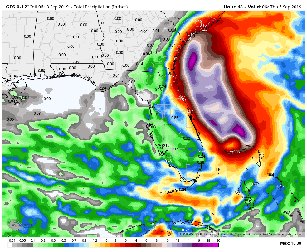
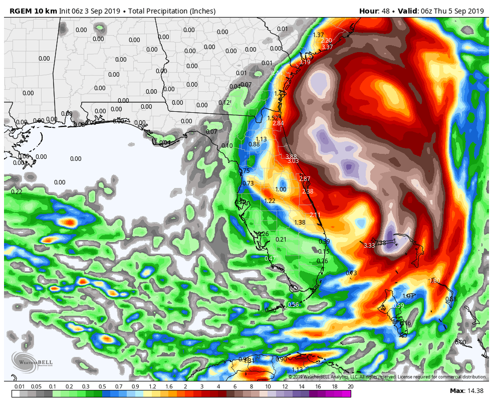
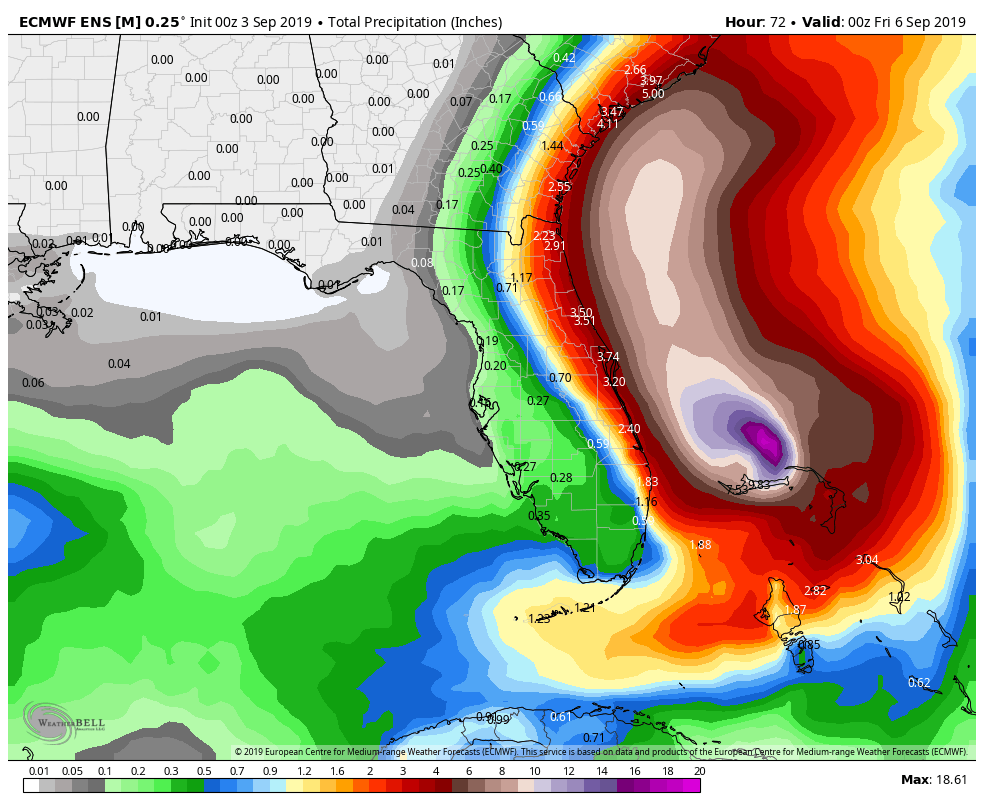
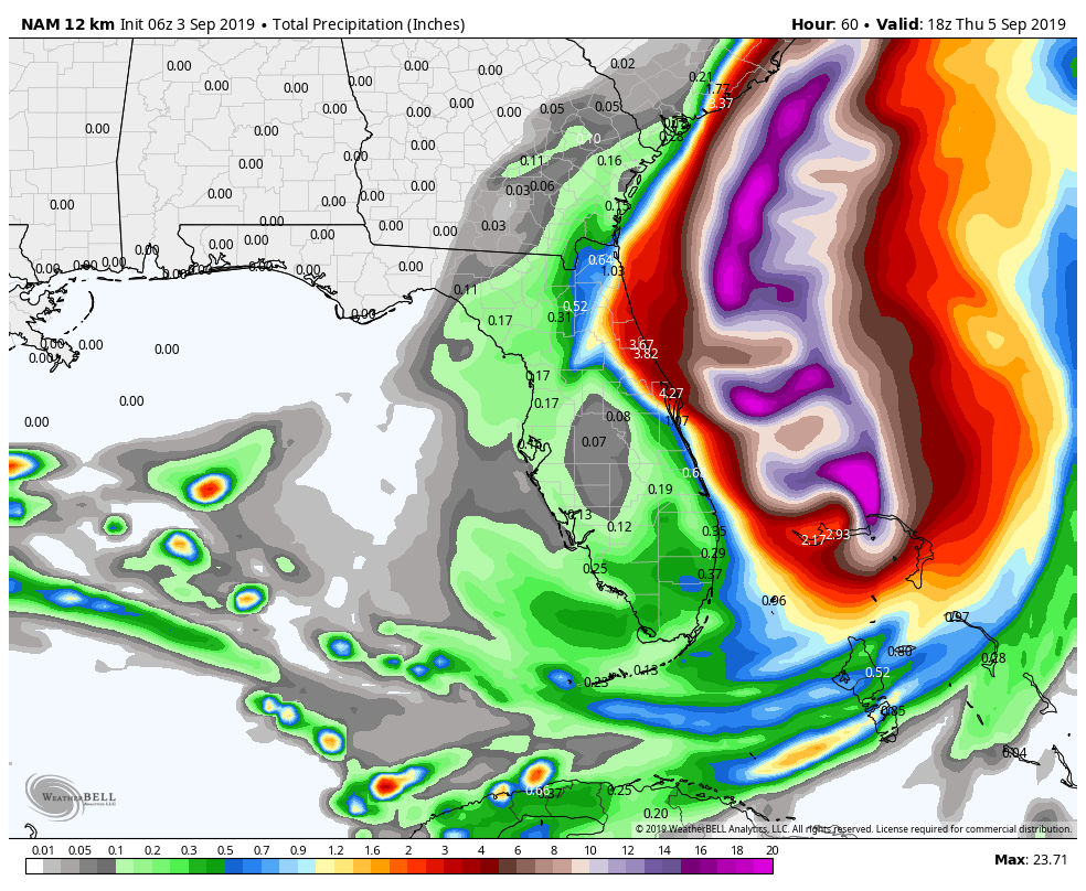
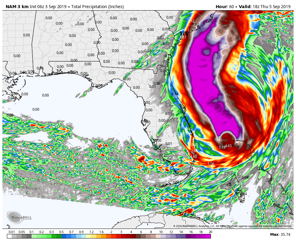
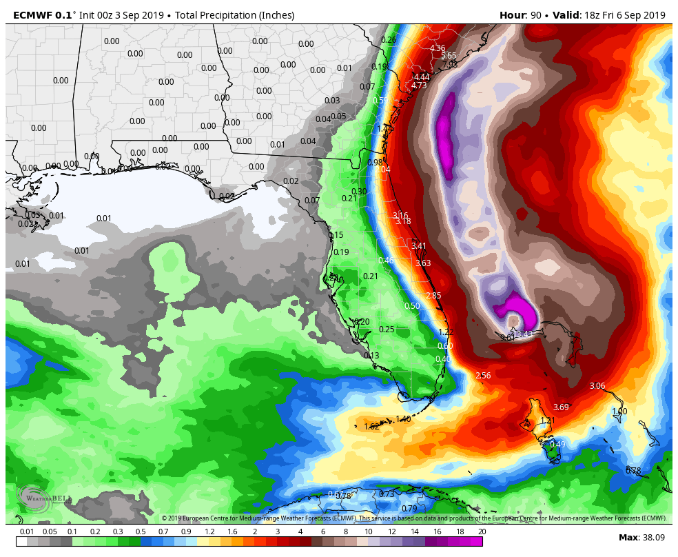
The models do not show a widespread 3-6″ rainfall with isolated 9″ totals for the coast of Florida. It looks more like 1-3″ of rain with an isolated 4″ amount, and there are some models that show even less. There’s a HUGE difference between two and six inches of rain. One is just a wet couple of days, the other is likely to lead to some flooding. I could be wrong, but if I had a client along the east coast of Florida, I would tell them to expect 1-3″ of rain with a slightly higher amount possible – particularly near the Space Coast.
The wind forecast is for “hurricane conditions” along the Florida coast, and the coast is under a Hurricane Warning. Yet again, the computer model information does not warrant a Hurricane Warning. In fact, when looking at the peak wind gust swath over the next couple of days, I cannot find a single computer model that offers a peak wind gust over 70 mph in Florida, never mind sustained winds that high. Look at the maps below.
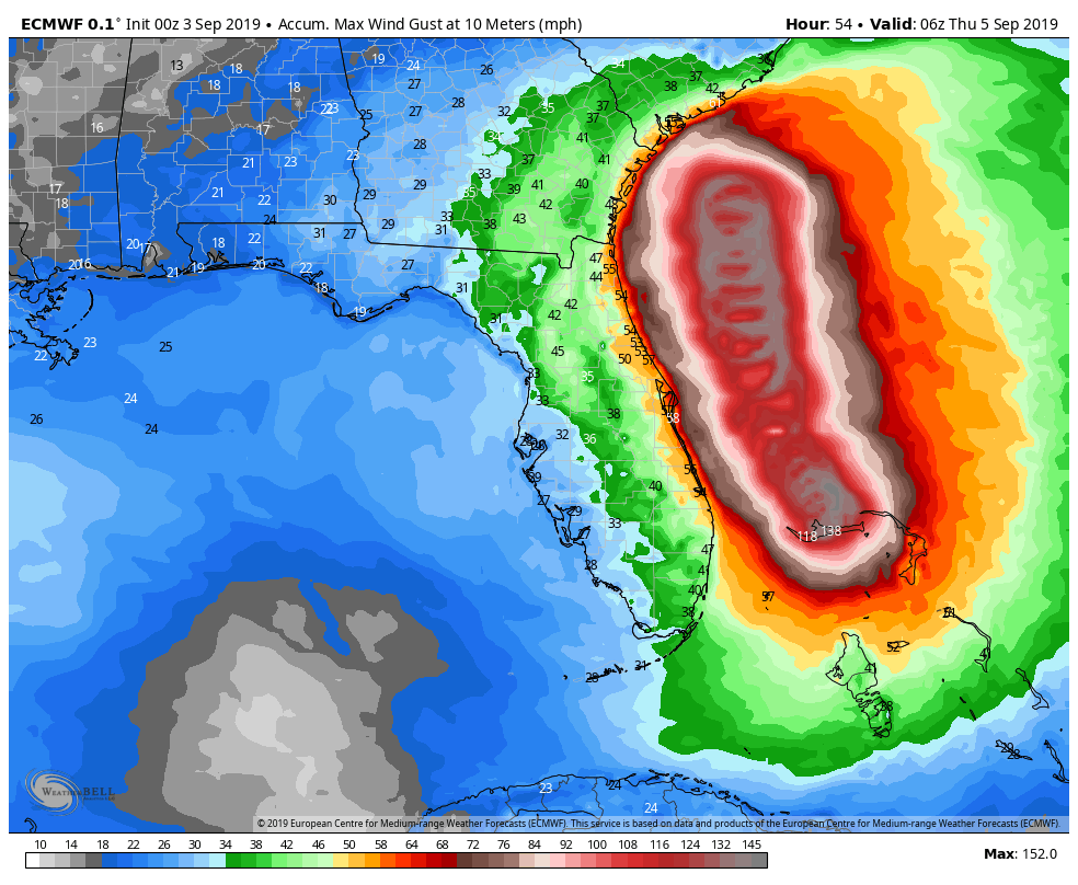
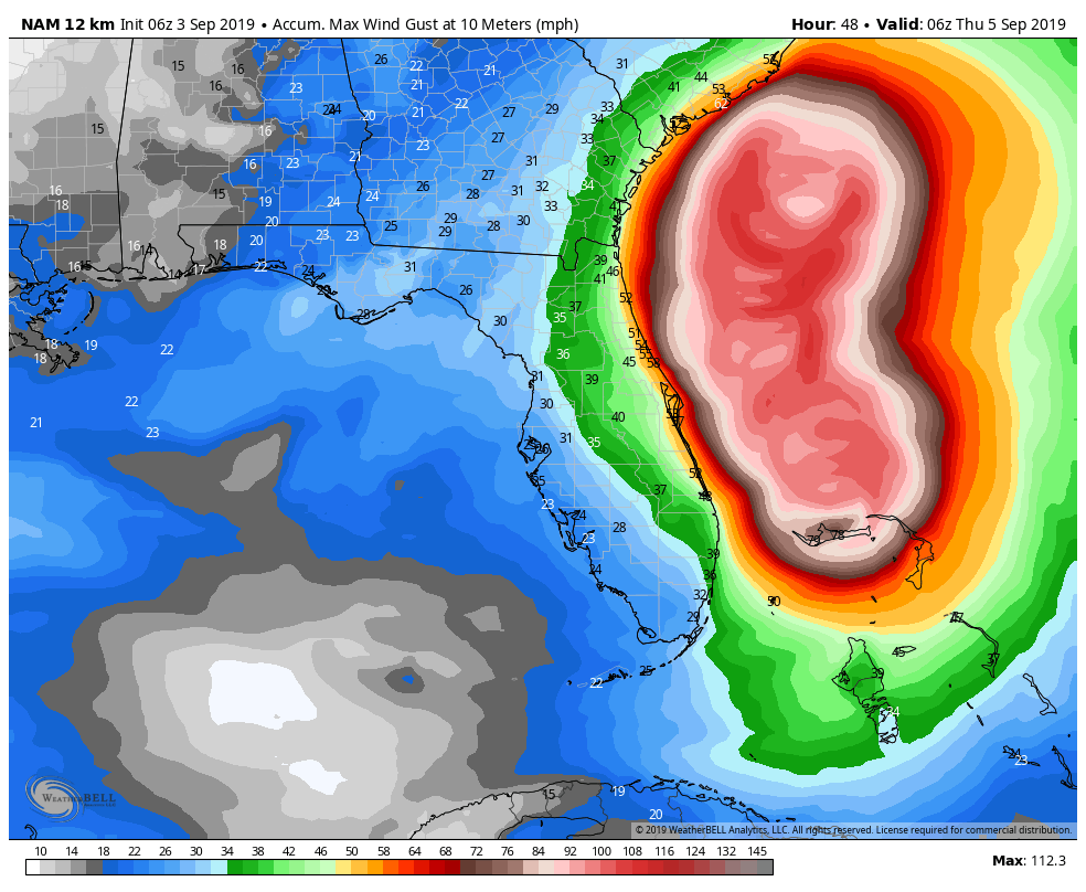
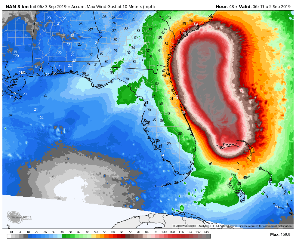
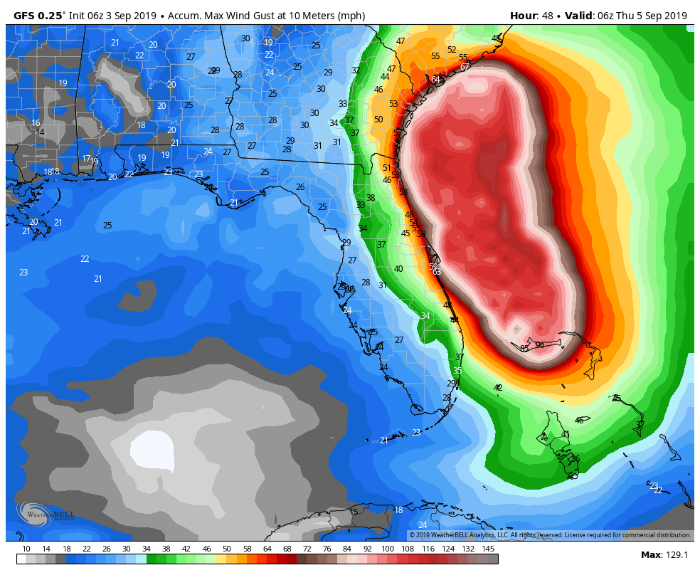
My question is pretty simple, how do you tell folks to expect hurricane conditions when the peak wind gust from four computer models for any location in Florida over a two-day stretch is 63 mph, and most areas see peak gusts closer to 55 mph? The risk that you run with a forecast that is not malleable as conditions change is the public not heeding your warnings for the next storm. It’s a bit of the boy who cried wolf. At one point, Dorian looked like a major threat to Florida, now it’s more of a glancing blow of wind/rain. However, the forecast has been slow to react to the changes and there are undoubtedly meteorologists on TV delivering forecasts warning of hurricane conditions and 6+” of rain for a large area that will likely not get close to that impact.
If anything, in my 20+ year career, I have been accused of downplaying weather events. I just try to call it like it is. I was all-in on Sandy and some big snowstorms in the past few years. There have been others, however, that I thought were being given a worst-case scenario forecast instead of the most likely scenario. I put Dorian’s impact in Florida in that category.
I think the storm is far a greater threat to the Carolinas, and there’s a chance it brings some squally rain to far Southeastern New England on the way by Friday PM into early Saturday. That part of the forecast is uncertain because we do not know exactly when Dorian will turn to the Northeast and race out to sea. If the storm does not make landfall in the Outer Banks of North Carolina, I think it will whip by New England practically unnoticed except for rough surf and big swells offshore. Unlike Nor’easters, tropical systems passing by out to sea usually do not have much action on the northwestern side of the storm – which would be closest to Southern New England. The wind field depicted below is unlikely to represent the actual wind field for Dorian on Saturday morning. I expect most of the wind to be on the eastern side of the storm as it falls apart over colder water while racing north. I will have more details on Dorian’s forecast for Southern New England in the next couple of days.


