The temperature reached 40° for the first time in over 10 days in Hartford on Friday. It hit the mid 40s near the coast. The milder air comes ahead of a storm system that will throw a one-two punch at Southern New England this weekend. The first swing looks like more of a miss with just a few showers around Friday night and Saturday. It will be gray and damp with temps in the 40s to near 50 at the coast. Skies will dry out briefly late Saturday before the second storm nears by dawn on Sunday.
The second storm is trickier because it will take a track that tends to bring snow at this time of the year. However, there is not much cold air around and it looks like a cold rain for most of Connecticut, Rhode Island and eastern Massachusetts. Inland and especially higher elevations away from the coast have the best chance of picking up some snow. It’s a very close call, and a track just a bit farther east or 1-2° C temperature change a few thousand feet up into the sky will make a big difference in the precipitation type that falls over Southern New England. The first rain or mixed precipitation arrives as soon as dawn in Connecticut and during the morning in Rhode Island and Southeastern Massachusetts. The steadiest precipitation is likely in the afternoon and at night. It will gradually end Monday morning.

National Weather Service snow forecast through 7 am Monday
There is a low likelihood for accumulating snow south of the green line on the map above. The best chance of seeing some snow is at the onset when it may be briefly mixed with rain, and again late at night or Monday morning as the storm moves away. I do not expect it to be cold enough or the snow steady enough to stick to pavement in those areas. Between the green and pink lines is a literal and figurative gray area. This area is most uncertain for precipitation type during the steadiest part of the storm. I am leaning towards mainly rain or at least enough rain that the final snow accumulation will be less than two inches, and probably closer to nothing. North of the pink line has the best chance of picking up 2-6″ of wet snow.
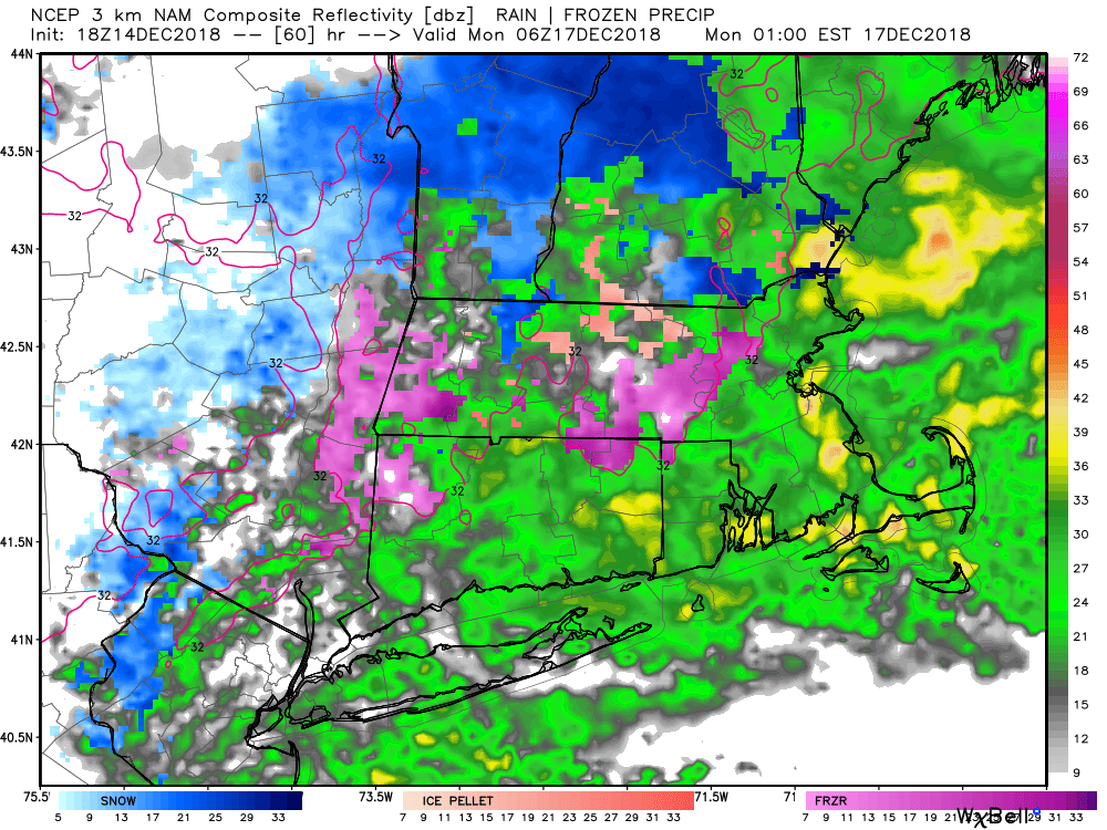
Radar forecast Monday 1 am EST – more rain than anything else, but it’s very close to being snow
At this point, the most widespread travel impact is possible during the Monday morning commute when colder air aloft is arriving as the storm departs. It could be snowy for a bit it in the I-95 corridor, with temps near or slightly above freezing. As the storm moves away, the temperature will rise well above freezing during the day.
So, it’s a close call, but this one looks like more rain than anything else for the Right Weather readers in CT, RI, and SE MA.
Tuesday looks blustery and cold with a few flurries possible. Highs will not be far from freezing, with wind chills in the teens to low 20s. Wednesday and Thursday will stay dry with a gradual warm-up to the mid-upper 40s by Thursday afternoon. A storm cutting to our west late next week brings rain and unseasonably warm temperatures on Friday.


