Hurricane Isaias is hitting the Bahamas on Saturday. It will get near Florida’s east coast on Sunday, and off the coast of Georgia and South Carolina on Monday. The storm will race up the East Coast bringing wind, rain and possibly coastal flooding to Southern New England Tuesday into Wednesday.
The storm is being hampered by strong westerly shear Saturday morning, and that is limiting its potential to strengthen. It will likely maintain Cat 1 or reach low Cat 2 status as is moves northwest in the general direction of Florida. It’s closest pass to Florida should be near the Space Coast. If it does not make landfall, then it may be able to strengthen some off the Southeast US coast. If it moves inland, tropical storm conditions are likely along the coast of Florida and Georgia.

Based on the latest information, I think the center of the storm may stay just offshore and spare Florida and coastal Georgia from significant wind/rain impacts. The storm may make landfall in South Carolina or North Carolina as it turns northeast. Looking at the latest trends, it seems to me that somewhere between Charleston, SC and the Outer Banks will be hardest hit by Isaias.
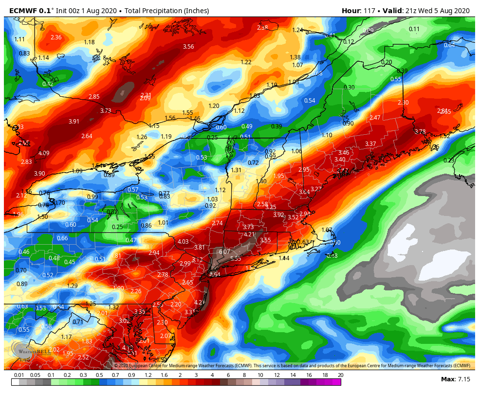
Regarding Southern New England, the storm will likely move over SNE sometime between late Tuesday and early Wednesday. It will most likely be a weakening tropical storm or post tropical cyclone when it passes by. Rain ahead of the system, mainly over the CT River Valley, followed by rain near the center of the storm, could lead to flooding in part of SNE. Right now, I think the best chance for 3″+ rain is in central and western CT and MA. That is based on a storm track over Eastern CT or RI. The heaviest rain will likely fall just west of the storm’s track, with much lower amounts likely to the east of the storm’s center.
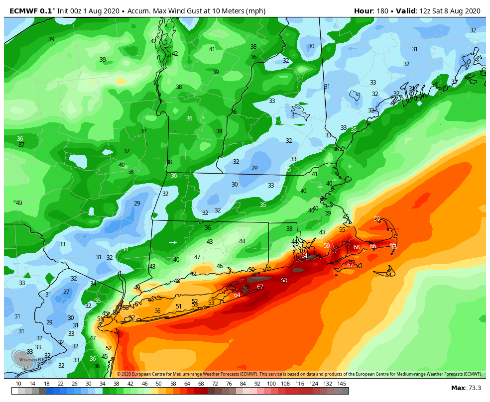
The strongest winds, however will happen along and east of the storm’s center. At this point, it looks like that will be over coastal RI and SE MA. It’s hard to know how strong the storm will be when it passes by since it’s still 1200 miles away, but gusts of 50+ mph are certainly possible given the computer model projections.
Coastal flooding is another concern along and east of the storm’s center. High tides near the RI coast on Tuesday evening and Wednesday morning could be even higher depending on when the storm passes by. At this point, a big storm surge is not expected, but some flooding is possible if Isaias is a tropical storm and the center passes near high tide.
If you’re looking for a couple of storms for comparison to Isaias, I suggest reading up on Bertha (1996) and Floyd (1999). While Isaias may be weaker than both of these systems, it could still have similar impacts. Bertha and Floyd both brought flooding rain and damaging wind to Southern New England. In a worst-case scenario based on the latest information, the hardest hit areas in Southern New England could get 5+” rain and wind gusts over 60 mph. As mentioned the heavy rain is on the west of the storm’s track, and the strong winds on the east of the storm’s track, so it’s an either/or situation, and I don’t see areas getting 5″ rain and 60 mph wind gusts.


