It’s hard to believe that it has been 19 years since September 11, 2001. The events that day changed the world forever. If you would like to read a recap of the weather on that day, I posted this eight years ago and it is the most read article on the site since then. This September 11 will be cool and breezy in Southern New England. The weather on Saturday morning will be similar to what happened on September 11, 2001 as a large area of high pressure settles over New England.
Look for dry skies Saturday and Sunday. There will likely be more clouds on Sunday. Highs both days will not be far from 70º. It gets a bit warmer on Monday as a front brings a scattered showers threat Sunday night into Monday, and cool air lags behind the front. The cool air rushes in Monday night into Tuesday. The temperature may reach the 40s at night in the countryside in the middle of next week. It will be dry and pleasant in the afternoon with highs in the 60s Tuesday and Wednesday. A gradual warm-up with dry weather is likely Thursday and Friday.
Tropics stay very active
Tropical storms Paulette and Rene are spinning in the Atlantic Ocean and there are several other areas that the National Hurricane Center is watching for development in the coming days. Paulette will likely become a hurricane and threaten Bermuda early next week. Rene is expected to stay in the open ocean and remain a tropical storm.
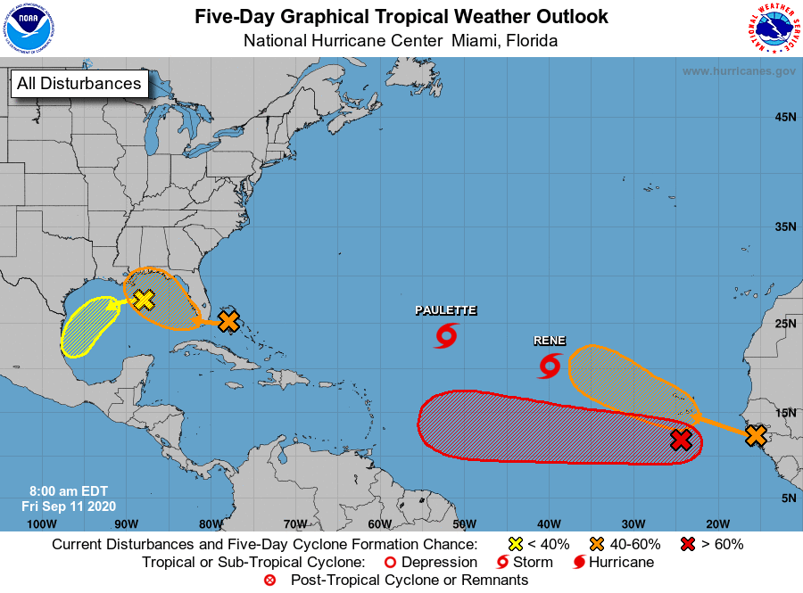
A couple of tropical waves not far from Africa have good potential to become tropical storms in the next 2-5 days. A disturbance over the Bahamas could become a weak tropical storm over the Gulf of Mexico by late this weekend. Another disturbance in the Gulf of Mexico has a low chance of development as it drifts south.
In the long-term, the system to watch is most likely the disturbance south of the Capo Verde islands off the coast of Africa. That looks like it could be long-lived tropical system that becomes a hurricane in the Caribbean and eventually threatens either the Gulf Coast or East Coast of the United States.
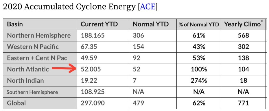
Interestingly, even though there have been so many storms this year, the amount of Accumulated Cyclone Energy is normal at the peak of the hurricane season. With the storms currently in the Atlantic Ocean, and more likely to form the ACE will be above normal for the next couple of weeks. The reason why it’s near normal at this point is because so many of the storms have been weak and short-lived this year. ACE takes into account storm longevity and intensity.