The temperature struggled to reach the mid teens on Friday afternoon, and it will be frigid under mainly clear skies Friday night. Lows will be within a few degrees on either side of zero to start the day. The temperature will climb through the single digits and teens into the low to mid 20s by midday as clouds increase. there will be a 5-10 mph south-southwest breeze.

Snow will develop during the afternoon, and it should be steady by sunset. Snow will continue through the evening, but the wind will not be strong because the storm that will bring the strong winds on Sunday will just be developing of the Southern New England coast. A few inches of snow may accumulate by late in the evening.
- Live Blog: Friday, February 13
- Storm Impacts Graphic
- NWS Issues Blizzard Warning for Eastern MA
- TV Station Snow Forecast Roundup
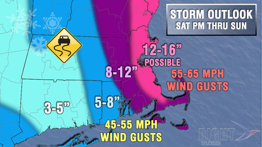
There is a chance of a lull from late in the evening until around dawn on Sunday as the storm rapidly intensifies off the coast. It will likely snow during that time, but it may be light and not accumulate much. Regardless of whether there is a lull, snow will fill back in around dawn on Sunday, and this time it will be accompanied by a howling northerly wind. Strong wind gusts are likely all day Sunday, and there may be blizzard conditions in Eastern Massachusetts in the morning. The snow may be heavy at times, especially in Eastern Massachusetts, in the morning. The temperature will fall from the 20s to the teens. The snow will end in the early to mid afternoon, but it will stay windy into the evening. Details on snow totals and peak wind gusts are in the graphic below.
It will become partly cloudy and frigid Sunday night. The temperature will fall to near zero by dawn on Monday, and the wind chill will be -10 to -25 early in the day. Monday afternoon will be partly to mostly sunny and frigid, with highs in the teens. The wind will relax during the day. It will stay bitter cold Monday night into Tuesday. Look for lows near zero again.
Clouds will increase on Tuesday ahead of the next storm system streaming out of the Southern states. The track of the storm is unclear, but it may come close enough for another plowable snow Tuesday night into Wednesday. For now, we’ll take it one storm at a time and focus on this weekend. We’ll keep you updated on the midweek snow potential in the next few days.


