Plenty of people would rather say “good riddance” to Sandy, then “so long”, but, regardless of how the storm impacted your life on Monday, the storm is going to be hanging around for a little while as the unwelcome house guest of the Northeast. Sandy was a huge and intense storm. You can’t just expect the most intense storm north of North Carolina in recorded history to dissipate quickly, right? Instead, what’s left of Sandy will be slowly spinning to the north and throwing showers and a gusty wind at a lot of the places that she wreaked havoc on, including Southern New England. It will be an occasionally soggy day, with a 15-35 mph south-southeast breeze. Highs will be in the low to mid 60s.
Showers are likely to continue to spin through Tuesday night into Wednesday. For those wondering about Trick or Treating, there is a decent chance that the showers will end in the afternoon, and it will be dry in the evening. It won’t be as mild on Wednesday, with highs struggling to reach 60 – which isn’t too bad for late-October. The tentative trick or treat forecast is partly cloudy and in the upper 40s to low 50s. Right now, the rest of the week, including the weekend, looks dry, but it will be cooler. The high temperature Saturday and/or Sunday may not make it to the low 50s.
Sandy’s Impact in Southern New England
I may do a reanalysis of the Hurricane Sandy forecast in the next couple of days, but on first blush, I thought it went pretty well. Based on what was happening Monday evening in New York City, Long Island, Connecticut, and New Jersey, the storm looks to have nearly lived up to its potential – which was nearly off the charts.
Lower east side of manhattan right now: #thisisnotajoke pic.twitter.com/e14I7VFV
— The Hoboken Girl (@thehobokengirl) October 29, 2012
Closer to home, it was a bit of a mixed bag. Very strong winds never materialized inland, and, as a result the power outages were scattered away from the coast. Still, though, as of 10 pm, more than 110,000 Rhode Islanders were in the dark. That’s many fewer people than with Tropical Storm Irene, but still a considerable amount considering the leaves were the trees in many spots and the wind had to be that much stronger to do damage. The wind was strong near the coast, with some 80+ mph gusts reported in Southern New England. Take a look at the link below for wind gust reports plotted on a map by the National Weather Service.
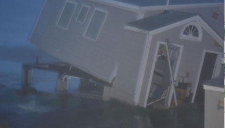
The full effects of the coastal flooding situation were not known as of Monday evening, but there were plenty pictures floating around on Twitter of storm damage near the south coast and around the bay. The surge was as high as predicted, but it’s hard to know exactly what that meant for area homes and businesses in low-lying areas. We’ll get a better look at the coastal flood damage on Tuesday.
https://twitter.com/__Robyn_/status/263063904912035840


