Nasty Nor’easter will bring midweek wind, rain, waves
Many areas that were very hard hit by Sandy haven’t even gotten to a point where they can begin the recovery process. Unfortunately, another storm, this time a Nor’easter, is targeting those hardest hit by the hurricane. The storm will spin up east of the Carolinas on Wednesday, quickly intensifying into a whopper of a storm capable of bringing some heavy rain, 60 mph wind gusts, moderate coastal flooding, and some snow for certain areas of the Mid-Atlantic and Northeast. Right now, as we told you earlier in the week on a Right Weather Pro update, it looks like Southeastern New England will be spared the snow, but will receive some of the strongest winds, along with periods of heavy rain, and another lashing surf and minor surge for the coast.

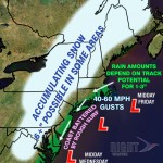
The map highlights some of the major threats from this storm. Notice, there is a better chance of snow in Washington D.C. and Philadelphia than in Rhode Island or Southeastern Massachusetts. That is because of the track of the storm being far enough off the Mid-Atlantic coast to hold some cold air in place over D.C. and Philly, but the strong east-northeast wind, and a track closer to the New England coast means rain for Boston and Providence. Worcester and points west still have the possibility of seeing some accumulating snow, and it will depend on close to the coast the storm tracks.
The storm will be a slow-mover, so it will dominate the weather scene in Southern New England from Wednesday afternoon through early Friday. The strongest winds with the storm may occur Wednesday night as it rapidly intensifies off the Mid-Atlantic coast.
Storm Impacts Rhode Island and Southeastern Massachusetts
- Long-duration event from Wednesday PM to Friday AM
- Potential for 1-3″ of wind-whipped rain. Best chance of 2-3″ is near the coast.
- Strong winds, capable of downing some trees or power lines. Strongest winds near the coast, gusts to 60 mph possible
- Minor to moderate coastal flooding possible for several high tide cycles beginning late Wednesday and lasting through Thursday night
The Mid-Atlantic will also get some nasty weather, with a better chance of some snow on the west side of the developing storm. The New Jersey coast will get strong winds, more coastal flooding, and some heavy rain.


