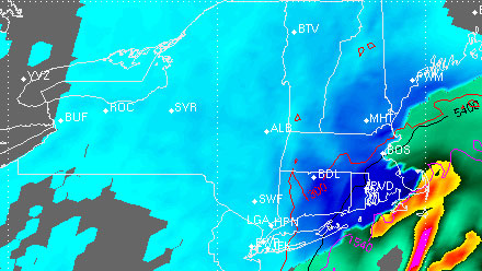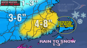
A quick-hitting, moderate snowstorm will move by Southern New England Saturday afternoon through Saturday night bringing the largest widespread accumulating snowfall fo the season to date. Snow should overspread CT by late morning, RI around noon or shortly after, and MA by mid-afternoon. There may be some rain or mixed precipitation combined with the snow at the coast from time to time this afternoon.
- Check out the Interactive Radar
- Live Blog for Right Weather Pro Members
- PatsCast: Blustery and cold at Gillette Stadium
The worst weather in RI will likely be between 5 pm – midnight as the “comma-head” of precipitation from the rapidly intensifying storm passes by. The worst in SE MA will between 6 pm and 1 am. Most of Southern New England will receive a plowable snow. The highest totals may be 8-12″ in a few locations from Newport to New Bedford to Bourne if the precipitation is all snow from start to finish. Many spots in RI and SE MA will will pick up a solid 6″ of snow.

The snow probability graphics have changed a bit for Providence area. There is still the greatest likelihood that the storm will total near 6″. There are lower odds, but not out of the realm of possibility, for higher amounts.

As new information rolls in this morning, much of it is suggesting higher amounts than Right Weather currently has forecasted for RI and SE MA. I’m not quite ready to go 6-10″ across the board, but it’s something that will be considered if the storm really starts to take shape to our south this afternoon. If you’re looking for a similar scenario to this one, I think the “December Debacle” of 2007 is a good analog. Many of us remember the gridlock that ensued when that quick-hitting storm arrived. The snow totals weren’t off the charts, but the frustration level was. If this storm is to produce on its full potential, then the snowfall rates will have to similar to that storm which lasted only 8-10 hours, like this one is forecast to.


