Light drizzle, rain, and freezing rain continues to fall Wednesday afternoon on the up to 5″ of wet snow that fell on Southeastern New England late Tuesday night into Wednesday morning. The storm will move away Wednesday night, but the next weather-maker is already on the map. A developing storm will move the Southeast to the Atlantic Ocean by late Thursday. It will move well east of Nantucket, but close enough to brush Southeastern New England with another round of snow.
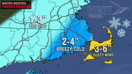
This time around, the areas that saw the least snow from the Tuesday night storm will get the most, and those that woke up to the most snow Wednesday morning, will wake up to the lowest amounts Friday morning. In short, Cape Cod, Martha’s Vineyard, and Nantucket will get a likely solid, plowable wind-driven 3-6″ of snow. The precipitation type is no concern with the Thursday night into Friday storm because cold air will be charging in from the northwest as the storm passes. As a result, even though the liquid equivalent of the snow will not be very high, a fluffy 2-4″ is possible in the I-95 corridor. The snow amounts will get lighter as you head west through CT and Western MA.

The snow should arrive around midnight and continue until shortly after dawn on Friday. It may linger until 8-10 am on Cape Cod. The wind will be gustiest on Cape Cod and the islands, where 30-40 mph gusts are likely. Don’t expect the snow to melt on Friday afternoon. The temperature will stay in the 20s, with wind chills near 10.
In case you have not heard, this is the start of a 3-4 week pattern that will feature plenty of very cold weather and several chances at accumulating snow in New England. Sign up for a Right Weather Pro membership to get the latest on long range weather trends, in-depth analysis, and custom event forecasts. At the very least, you should download the FREE RightWX app for your iOS or Android device!


