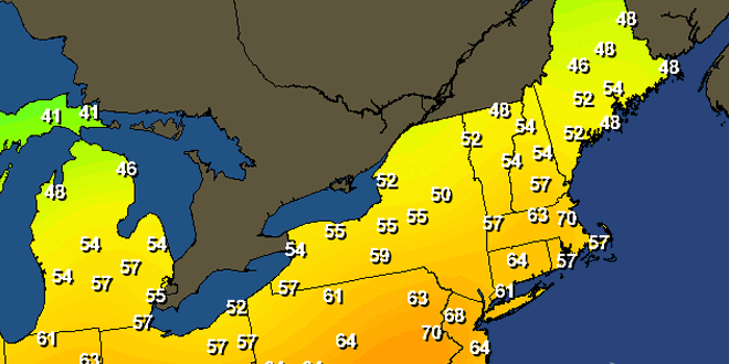
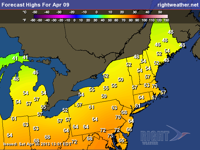
The gusty north-northwesterly wind had it feeling a bit cool for early-April on Saturday. The high temperature did not make it to 50 degrees in most spots. The wind will relax Saturday night, with the temperature falling into the upper 20s to low 30s under clear skies. Sunday should be a pretty nice day with partly sunny skies and highs in the low to mid 50s. The wind will increase during the afternoon, gusting to 25 mph out of the south-southwest near the coast. The onshore breeze will cool the coast quickly by mid to late in the afternoon.
A decent warm-up is ahead for Southern New England early next week. Monday will be partly to mostly sunny with highs in the low to mid 60s inland, and 50s near the coast because of an onshore wind. A warm front will move through early Tuesday, and if skies clear by mid-morning, the high temperature will reach 70 inland. Once again, it will be about 10-15 degrees cooler near the coast because of the wind direction.
There is some uncertainty about whether a stationary front will be north or south of Southern New England Wednesday and Thursday. Right now, it looks like most of the area will be on the warmer side of the front Wednesday, and cooler side on Thursday. The difference between the warm and cool side of the front is 10-20 degrees. The forecast is for highs in the 60s inland on Wednesday, and low to mid 50s on Thursday.
A storm system should bring some late-workweek rain. At this point, the timing of the rain looks like Thursday night into Friday, with drier air moving for next weekend.


