Long-Range Forecast – May 15

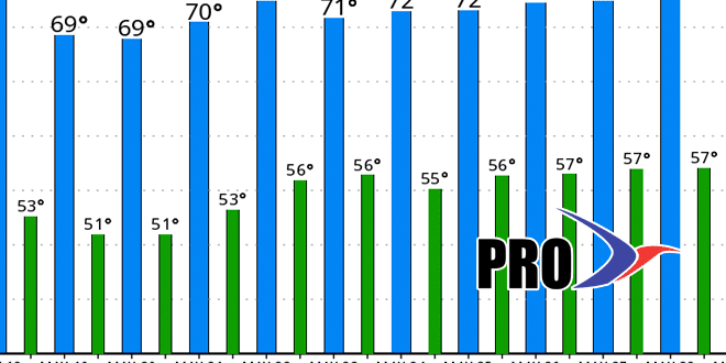
The first half of May has been relatively dry and warm in Southern New England. After an inch-plus of rain on the first day of the month, there has been less than one-tenth of an inch in the Providence area in the last two weeks. Of course, heavy showers are in the forecast for Friday night into Saturday, and it should be enough rain to get the monthly precipitation total back on track. As for the relatively warm start to the month…it does not look like there is much, if any, 80°+ warmth in the forecast of the next couple of weeks. There may be the occasional warm day, but most of the time the high temperature should be near or slightly below normal. The low temperature, however, will most likely be above normal, and we’re pretty confident that May will end the streak of colder than normal months that dates back to last November.
It looks like the rain will move through fairly quickly on Saturday. The afternoon may turn out to be decent in Southern New England. A storm will develop east of New England Sunday into next week, but the impact from it looks lower than what we were expecting earlier in the week. A few showers are possible Sunday afternoon, and showers can’t be ruled out Monday or Tuesday, but most of the time it should be dry.
We will be on the lookout for another round of rain late next week or early in the Memorial Day weekend. Overall, there is no big warm-up in the forecast, but the temperature, as noted above, will not be too cool, either. The daytime highs in the graphic below are near to slightly above normal for the most part. The low temperatures are several degrees above normal in most cases.


