Monday’s snowstorm over-performed a bit in Southern New England. Snow totals ranged from 2-6″ by late in the afternoon, with the higher totals near the coast. The snow will taper off to flurries after sunset, and should end completely by mid-evening. Skies will clear after midnight, and the temperature will drop to 20-25° by dawn Tuesday.
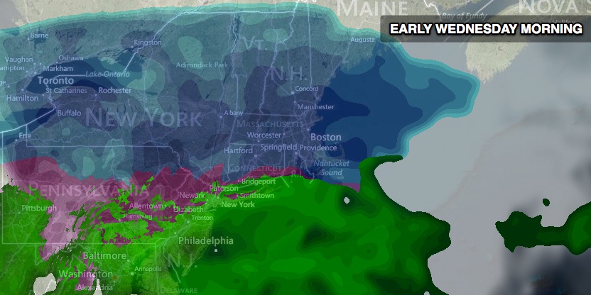
Tuesday looks like a relatively quiet day, with seasonably cool conditions and a slowly increasing afternoon clouds. Highs will be in the mid 30s. Another storm will be cranking up in the Midwest heading east. Clouds will thicken Tuesday night, and snow is likely before dawn on Wednesday. This storm has the potential to come in fast and furious with accumulating snow from the onset. At this point, we think the Wednesday morning commute will be slowed considerably by moderate to heavy snow in all of Southeastern New England. A Winter Storm Watch is in effect for Southern New England.

The big x-factor with Wednesday’s storm is the potential for sleet and freezing rain to get involved if milder air arrives a few thousand feet up in the atmosphere. It is a very close call between all wet, heavy snow in the I-95 corridor or a burst of snow followed by a change to sleet and/or freezing rain. Right now, we’re leaning to several inches of snow accumulating before any mixed precipitation arrives. Further inland, the snow may hang on for most of the storm – at least during the heaviest precipitation.

This will be a moderate to heavy winter storm for Southern New England. The higher elevations away from the coast could pick up 10-12″ of snow between 4 am – 7 pm Wednesday. In the I-95 corridor, we’re expecting closer to 6″ with some sleet or freezing rain Wednesday morning. Near the coast, there is a better chance of sleet, freezing rain or rain at times during the day Wednesday. It is a wicked close call for precipitation type in Southeastern New England. The heaviest precipitation is likely before 1 pm Wednesday. Lighter mixed precipitation or snow may linger into Wednesday night. The temperature will gradually fall back through the 20s.
The wind will be stronger than it was during Monday’s snow. It does not look like there will be damaging wind, but gusts over 30 mph are possible near the coast. The main wind direction during the storm will be east-northeast. Inland locations should see 10-20 mph winds. Temperatures will be in the upper 20s to low 30s during the storm.
Cold and dry weather is ahead for the end of the workweek and first half of the weekend. Thursday may not make it out of the 20s with partly sunny skies. Friday and Saturday should both be mainly clear to partly cloudy with highs in the low to mid 30s and lows in the teens.
Our antennae are already raised on the potential for another storm late in the weekend. Sunday is the anniversary of the 2013 blizzard, and it looks like there could be another significant winter storm Sunday into Monday. It’s very early in the game, but the computer models are in decent agreement on a moderate to heavy precipitation event. It’s way too early to talk precipitation-type, timing, and totals, but we’ll continue to watch the forecast very closely.


