
The latest computer model guidance indicates a storm that rapidly intensifies as it hits the Atlantic Ocean off Cape Hatters on midday Saturday. The storm will be a fast-mover, so the window for heavy, accumulating snow is a small one in Southeastern New England. There is also the factor of the storm’s track, with the heaviest precipitation taking place close to the center of the storm. But, if the storm tracks too close to Southern New England, then some areas near the coast may see rain or mixed precipitation instead of snow due to some warmer air getting involved at the surface and/or a few thousand feet up into the atmosphere.
Most reliable computer models have the system undergoing “Bombogenesis” – which means the pressure will drop more than 24 mb in 24 hours. This is likely to be an intense storm as it races southeast of Nantucket Saturday night. The key is it will be racing, and not stopping to deliver 8-12 hours of heavy snow on Southern New England. Rather, it looks like the moderate to heavy snow window in RI is 5 pm to 1 am, and maybe even 7 pm-11 pm. It’s a bit later in SE MA, especially on Cape Cod, where the height of the storm will be from 8-9 pm until 3-4 am.
- Snow probability forecasts for the Providence area
- NWS issues a Winter Storm Watch for part of SNE
- PatsCast: Dry, windy, and cold at Gillette
- A roundup of the Friday evening Providence and Boston TV station forecasts
- Interactive Radar with buoy and surface observations
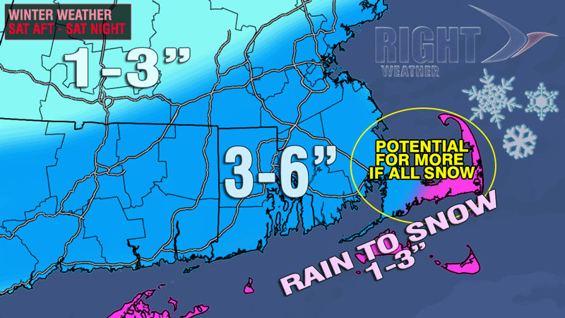
The GFS, NAM, and Canadian model all have a rather tight precipitation gradient. That means that you won’t have to travel a very long distance to go from light amounts of precipitation to heavy amounts. In the Providence area, the GFS and NAM both print out about 0.5″ of precipitation. If that’s all snow with a 10-1 snow ratio, then the Providence area will get roughly 5″. The precipitation is lighter in Northern RI and Worcester county, but there could be a slight fluff factor that keeps the snow totals in the same 3-6″ ballpark.
Near the coast, the precip. totals range from 0.75″ in Newport to more than an inch on Cape Cod. The $64,000 question is will those heavier amounts from Newport through Buzzards Bay and Eastern MA be all snow or a mix of snow and rain. Right now, I think a bit of mixed precip. or rain is involved, and the final totals may not be appreciably higher than the Providence area. The only change I’m considering for the accumulation map would be to throw in some isolated 6-8″ amounts a few miles inland on a west to east line from Washington County to the Cape Cod Canal.
The storm timeline hasn’t changed much. If anything, I think the onset may be delayed an hour or two. So, instead of 11 am – 1 pm in RI and SE MA, it may be more like 12 pm – 2 pm for the first flakes, ice pellets, and raindrops. The steadier, heavier precipitation may take a few hours to develop, so, if you have stuff to get done and don’t like driving in snowy weather, it’s best to plan on being off the roads by 2 pm.


