This is a Right Weather Pro free preview. Computer Model Trends is a regular installment when a major storm is pending, and it is typically posted 1-2 times daily. There is a lot of technical information in this update, but it can give you an idea about how we come up with our forecast. If you like what you see, then consider purchasing a Right Weather Pro subscription for just $39.99/year. That’s about $.11 a day and you get much more than just pre-storm analysis and in-storm coverage. There are seasonal, long range, and custom event and vacation forecasts, too. The Live Blog during the Blizzard will only be available to the growing community of Right Weather Pro members.
Feel free to ask any questions in the comment section at the end of the blog. Click to enlarge all images.
A few things:
12Z run = 7 am EST initialization time
00Z run = 7 pm EST initialization time
QPF = Quantitative Precipitation Forecast (how much liquid precipitation falls – must convert for snow totals)
This page will be updated as the models arrive. Refresh the page frequently for the latest updates.
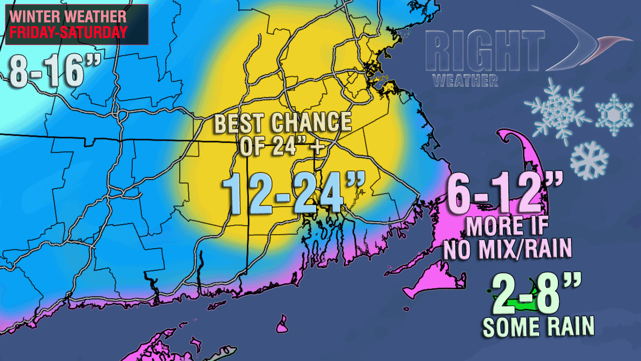
Here is the current Right Weather accumulation map
00Z ECMWF – European
The European stayed the course with a major snow storm for Southern New England. Snow totals are a bit less than prior runs, but still 18″+ for most of Southeastern New England, with some pockets of 24+”. The storm was a bit more progressive than prior runs, with the heaviest snow coming to an end by mid-morning in RI, and early-afternoon in SE MA. Winds gust 60-80 mph from late Friday night until midday Saturday from the coast to I-95 – the highest gusts would likely be near the coast. It’s bitter cold Saturday, with temperatures in the teens to mid 20s.
00z GFS – Global Forecast System
The GFS has been a little more tame, and some might say realistic, than some other models regarding this storm. The 00z run stays the course with exactly 1.5″ of QPF in Providence. Sorry folks, but if this model is correct, there will not be two feet of snow in the Providence area. 1.5″ of liquid would yield about 14-18″ of snow. A big storm, but not in the top-5 all-time, and maybe not in the top-10. Of course, this is just one of many different computer models, so there is no guarantee that this model will be any more accurate than the NAM, ECMWF or some of the others.
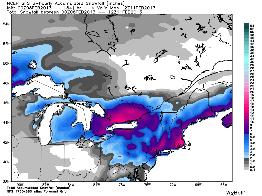
Basically, the GFS has a snow storm across the board for Southern New England, with a widespread 10-18″ in RI and SE MA. It’s a lot more progressive than the other models, with the storm departing quickly Saturday morning. If you’re not looking for a paralyzing blizzard, and most of aren’t, than this is the model for you.
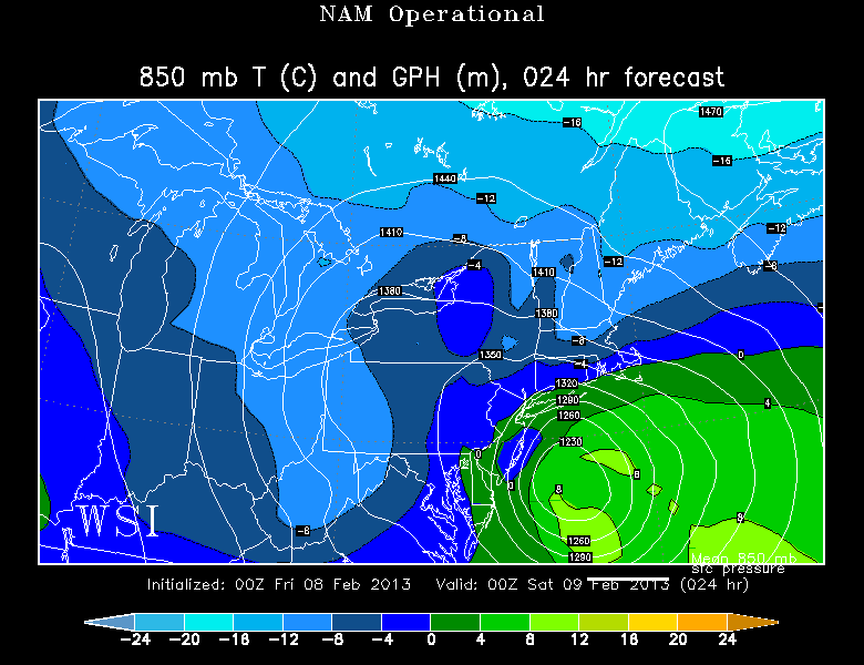
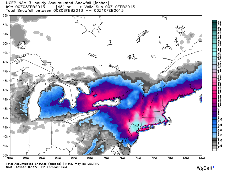
00Z NAM – North American Model
A few days ago this model was showing very little interaction between the northern and southern branches of the jet stream, and it wasn’t producing much of a storm. Then, yesterday, it came on board with a major blizzard, but it overdid it a bit with 40-70″ of snow in New England. Needless to say, the model has been much maligned this week by meteorologists who take great pleasure in bashing this high resolution, short-medium range model.
The 00Z run of the NAM is the first computer model run that we get see using all the new data that was collected via weather balloon launches that occurred at 00Z (7 pm EST).
The total QPF (liquid precip) from the model in the Providence area is about 2.6″. That would translate to about two feet of snow! The model has the storm cranking into Saturday morning before slowly drifting away Saturday afternoon.
One of the things that I’m concerned about with the NAM model run is the possibility of a dry slot of air working into RI and SE MA because the center of the storm gets so close to Southern New England. We’ve seen it before, and it can turn a 20″ forecast into 12″ – not a bad storm, but not apocalyptic! The center of the storm on the NAM track actually passes right over Nantucket. That is awfully close for an all-snow storm in all or RI and interior SE MA.
With the 00Z NAM track, the strongest winds are on Nantucket, but the longest duration of strong winds occurs on Block Island. 18+ consecutive hours of 40+ mph winds are possible from late Friday afternoon through midday Saturday. Peak wind gusts would be hurricane force somewhere between the RI coast and coastal SE MA late Friday night. Best odds are on Cape Cod.

More analysis on the next page…


