The weekend storm is trending toward an overall lower impact in Southern New England. The storm still has the potential to bring a plowable snow to parts of Southern New England, but a farther south track means the heaviest precipitation stays offshore. The brunt of the storm will be Saturday night, and it is still somewhat unclear as to whether it will be snow or rain that falls by late Saturday evening in the Providence area.
Friday night looks partly to mostly cloudy, and not terribly cold, with lows in the mid to upper 20s. Clouds will thicken on Saturday with highs in the mid to upper 30s. A wintry mix will develop late in the afternoon from west to east. For most, the precipitation during the first few hours of the storm will be snow. 1-4″ of snow could accumulate from south to north by mid to late evening as the storm continues to move to the northeast off the Mid-Atlantic coast. The best chance of more than 2″ of snow is north of Providence.
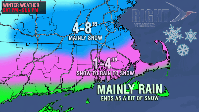
As milder air arrives during Saturday evening, the precipitation will change from snow/mix to rain from the coast to roughly the Providence area east to Plymouth, MA. Temperatures will be in the low 30s where it stays all snow, and in the mid 30s where it changes to rain. Late at night or Sunday morning, as the storm departs and colder air arrives, there may be a change back to snow – especially away from the coast. A minor accumulation is possible during the day Sunday. The best chance of picking up any accumulating snow on Sunday is northeast of Providence towards Boston. Highs will be in the 30s on Sunday. Snow showers or light snow may continue Sunday night into Monday bringing an inch or two to most of Southeastern New England.
Final snowfall totals will be minor to moderate throughout Southern New England. The immediate coast will see mainly rain. A few miles inland to the Providence Metro area and most of interior SE MA has the potential for 1-4″ of snow, with the best chance of seeing the higher amounts coming the farther away your get from the ocean. North of a Hartford, Providence, Plymouth, MA line stands the best chance of picking up about 6″ of snow through Sunday afternoon. Enough to plow, but certainly not the biggest storm this month!


