Saturday was another mostly sunny, warm, breezy and muggy day in Southern New England. The Providence area, however, came up just shy of the first heat wave since July of last year. The high temperature at TF Green was 89° – one degree short of the 90° that was need for a third consecutive day of 90°+ and an official heat wave. The high was also 89° in Taunton, also just one degree short of a heat wave. Boston hit 90°, but for only the second consecutive day. It was a heat wave in Hartford, CT where the temperature reached 90° for the third consecutive day.
Saturday night will be mild and muggy with patchy fog developing – especially near the coast. The low will be in the low to mid 60s near the coast, and mid to upper 60s inland. There should be some sunshine after early fog burns off by mid-morning on Sunday. It will not be quite as warm as the past few days, and the wind will increase out of the south to 15-25 mph by noon. Highs will be in the low to mid 80s inland, and in the 70s near the coast. The weather may deteriorate in the afternoon near the coast. A strong southerly wind at 15-30 mph is likely, and there may be some low clouds and fog that roll into the south coast by 4-5 pm. If there are no low clouds, the temperature will be near 70. If the clouds/fog develop, there will be a bit of a chill in the air with the strong winds and temperatures in the 60s.
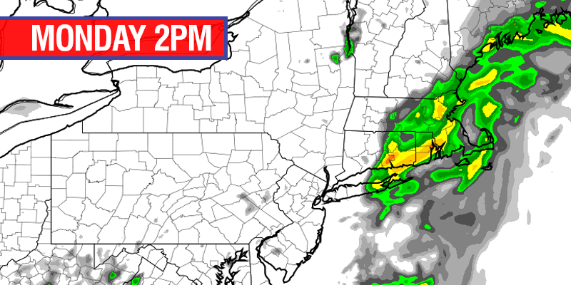
Showers should hold off until Sunday evening, and possibly until after midnight or early Monday morning. A line of strong thunderstorms should weaken as it moves into the maritime air over Southeastern New England Sunday night. It will stay muggy, with lows in the 60s and a gusty southwesterly breeze. The front will move through very slowly on Monday, and showers and thunderstorms are possible in all of RI and SE MA until late in the day. The high temperature will be close to 7o.
The cold front will move offshore by dawn Tuesday, and dry, pleasant weather is in the forecast through the midweek. Tuesday through Thursday should be mainly clear, with lows in the 50s and highs in the low to mid 70s – just about normal for early-June. Looking ahead to next weekend, we’ll have to keep a close eye on what happens in the Gulf of Mexico next week. It’s possible a tropical system could get scooped up by an approaching cold front and bring showers and thunderstorms next weekend.


