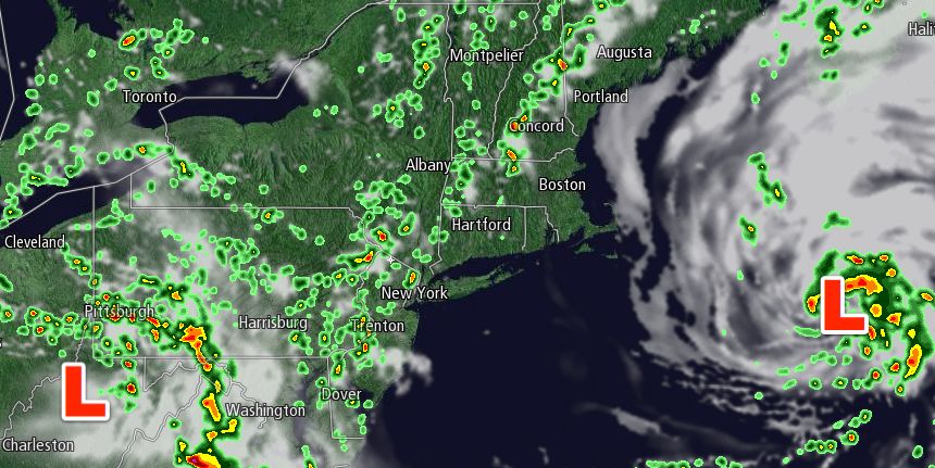
Tuesday afternoon turned out to be quite nice in most of Southern New England after the locally drenching rain moved out of the picture. Some areas received 2-3 inches of rain as a developing storm passed overhead Monday night and early Tuesday. By mid-afternoon, the storm was in the Atlantic Ocean and skies were partly cloudy. The temperature reached the low to mid 80s inland. It stayed in the 70s near the coast.
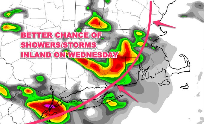
Locally dense fog was rolling into Eastern MA Tuesday evening, and there will be some clouds and fog early Wednesday. Any low clouds should burn off to partly sunny skies by late Wednesday morning. The afternoon will feature clouds and sun with the chance of passing showers and thunderstorms – especially inland. Highs will be in the low to mid 80s inland, and 70s near the coast and in E MA where the wind will be onshore. It will remain somewhat humid in all of Southern New England.
The threat of showers and thunderstorms diminishes after sunset. Patchy mist and drizzle is possible Wednesday night. The temperature will drop into the low to mid 60s with a light northeast breeze. Thursday looks similar to Wednesday, with a blend of clouds and sun, and the chance of passing afternoon showers or t-storms. It will likely be a few degrees cooler on Thursday. Highs inland will be in the low 80s, and it will be in the 70s near the coast.
The forecast for Friday through the Labor Day weekend is challenging. Friday looks partly sunny with highs in the mid to upper 70s. A slow-moving disturbance will enter the Eastern United States during the Labor Day weekend. Right now, it is uncertain how far east the disturbance will be during the early to middle part of the weekend.
In a worst-case scenario, afternoon showers threaten on Saturday, with the chance of showers and storms on both Sunday and Monday. In a best-case scenario, it stays dry Saturday and most of Sunday, with a better chance of showers and storms on Labor ay. At this point, our forecast leans towards scattered PM inland showers on Saturday, widespread showers and thunderstorms on Sunday, and scattered showers on Monday. There are still several days before the weekend, and it is a low-confidence forecast. Check rightweather.com for more updates on Wednesday.


