It is going to be a wild weather week in Southern New England with the coolest weather since late-May and potentially the hottest since mid-July occurring within 50 hours of each other. Monday morning was the coolest (48°) at TF Green Airport since May 28. The temperature reached the mid to upper 60s in the afternoon with filtered sunshine.
The temperature will be in the mid to upper 50s to start the day on Tuesday. Skies will be mostly cloudy as a warm front slowly moves north from the Mid-Atlantic to New England. That front will take its sweet time punching through Southern New England, and clouds may be stubborn through most of the day. Widespread showers are not expected in Southern New England. The temperature will slowly climb through the 70s in spite of the clouds. At the same time, it will be getting muggier. Dew points will reach the mid to upper 60s by Tuesday evening.
Humid and hot inland in the midweek
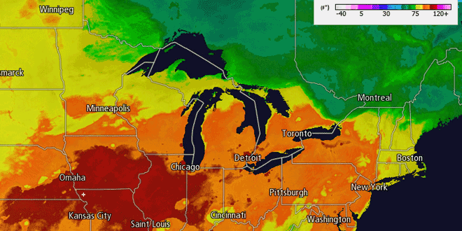
Tuesday night looks mostly cloudy, mild, and muggy with patchy fog near the coast. The weather will be decent for the Portugal vs. Brazil soccer match at Gillette Stadium Tuesday night. Lows will be in the mid to upper 60s. Low clouds and fog will burn off Wednesday morning. The 90°+ degree heat that has scorched the Midwest in the last couple of days will reach the Northeast on Wednesday. The high temperature on Wednesday in Southern New England will be determined by two factors: how quickly the clouds burn off, and the wind direction.
Right now, it looks like there will be enough sunshine and a favorable wind direction for some 90°+ heat inland. The last time the temperature reached 90° in Providence after September 10 was in 2005. Near the coast, the clouds may be slower to erode, and the wind will be out of the southwest. That will keep the temperature near the coast in the upper 70s to low 80s. A strong southwesterly wind in the afternoon will drop the temperature into the low to mid 70s by late in the day.
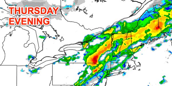
Wednesday night will stay quite mild and muggy. More patchy fog and low clouds will develop – especially near the coast. Lows will be in the upper 60s to low 70s. While very warm and humid, Thursday will likely not be as hot as Wednesday. Highs will be in the 70s near the coast and 80s inland under partly cloudy skies. Showers and thunderstorms are possible in the afternoon and night as a strong cold front plows into the Northeast.
The front will be offshore by early Friday morning putting an end to the thunderstorm threat. Friday afternoon looks partly sunny with highs in the low to mid 70s. Cool weather will continue to pour into the Northeast Friday night into the weekend. Saturday will become partly cloudy with the chance of pop-up showers due to the unseasonably cool air in the upper levels of the atmosphere. Highs Saturday will only be in the low to mid 60s. A far cry from the midweek heat and humidity! At this point, it looks fair and seasonably cool on Sunday. Lows will be in the 40s with highs in the 60s.


