Howling winds and frigid temperatures joined to give wind chills in the single digits to low teens all day Sunday. It was not a run of the mill cold day, with record low maximum temperatures tied or broken in Southern New England. Winds gusted to near 50 mph and caused downed trees and branches in New England.
The wind stayed active into Sunday evening, and it will gradually diminish to 10-20 mph by dawn Monday. It will be a bitter cold night with lows in the teens in most spots. Wind chills early Monday will be between 5-10°. Monday should feature a lot of sunshine, but it will stay unseasonably cold, with highs only in the low to mid 30s. The wind will kick up to 15-25 mph in the afternoon. Clouds will gradually increase Monday night. It will not be as cold, with lows in the mid to upper 20s.

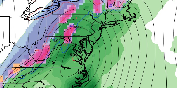
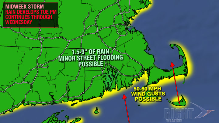
A storm will move out of the Gulf of Mexico and up the Eastern Seaboard in the middle of the week. Although a rain storm for the big cities, the storm will most likely have travel implications up and down the East Coast. Rain will develop late Tuesday, and become heavier by early Wednesday morning. Moderate to heavy rain is likely Wednesday morning. The storm may also produce strong winds near the coast. The strongest winds will likely be just to the east of the storm’s center. The best chance of 50 mph gusts is east of Newport to Cape Cod, including the islands. It will become much milder in spite of the rain on Wednesday. Highs will be in the 50s.
Rain will continue into Wednesday evening before ending Wednesday night. A brief change to snow before the precipitation ends is possible, especially inland. Snow accumulation is unlikely with wet pavement and temperatures above freezing. The temperature will eventually fall into the upper 20s to low 30s by dawn Thursday after the precipitation ends. Thanksgiving looks blustery and cold, but mainly dry. A few flurries cannot be ruled out in the morning, and the afternoon should be partly cloudy. The temperature will be in the low 30s, but it will feel colder due to a 15-35 mph northwesterly wind.
Black Friday will be dry and chilly. Lows will be in the teens, and highs will only be in the 30s. There should be a decent amount of sunshine, and the wind will be lighter than on Thursday. The early outlook for next weekend is for more cool and mainly dry weather.


