A developing storm will roar up the Eastern Seaboard on Wednesday bringing heavy rain and strong wind to Southern New England. The storm has the potential to cause street flooding and wind damage in all of RI, CT, and MA. A widespread 1.5-3″ of rain is expected, and a the hardest hit areas may get 4″ of rain – more than most of Southern New England has received in the last 2.5 months!
- Download the free RightWX app for you iOS or Android phone or tablet
- Check out the Interactive Radar for the latest on the storm
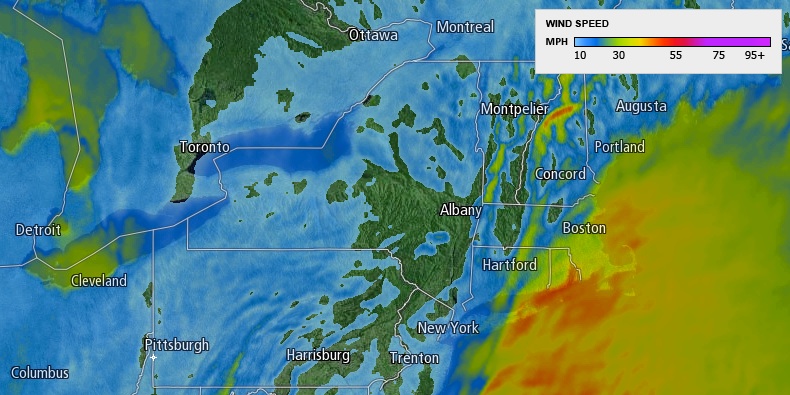
Peak wind gusts near 60 mph are possible Wednesday morning. By comparison, the peak gusts this past weekend were generally between 45-55 mph. The National Weather Service has issued a Flood Watch and a High Wind Warning for part of Southern New England.
Storm Impacts
Rain
Rain will develop Tuesday evening and will become moderate to heavy by dawn Wednesday. Locally heavy rain is expected in all of Southern New England through Wednesday morning. There may be a lull in the action around midday before a last round of moderate to heavy showers moves through late in the afternoon or early in the evening. The rain will quickly taper to showers during the evening. A few snow showers or flurries may develop as colder air moves in late Wednesday night. No snow accumulation is expected. Final rain totals should be between 1.5-3.5″ for most of Southern New England. The favored area for more than 2.5″ is in Eastern CT and Western RI. A few spots may receive 4″ of rain.
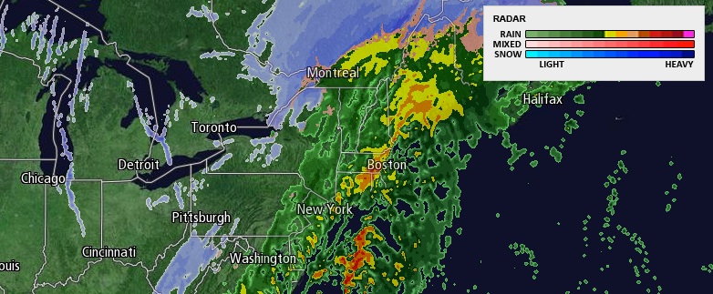
NOAA Rain Forecast
Wind
The wind will be screaming just off the surface. Hurricane force winds will be occurring 500-1000 feet above the ground. 20-40 mph sustained winds are likely Wednesday morning, with the strongest sustained winds near the coast. There is the potential for some of the stronger winds above the surface to mix down to the ground. That is why a High Wind Warning is in effect for most of RI and SE MA. Peak wind gusts approaching 60 mph could cause downed trees and power lines. The peak winds will occur in all but Cape Cod Wednesday morning. The wind will stay very strong on the Cape into the afternoon.
The wind will increase again late Wednesday night as the storm intensifies in Eastern Canada. 15-35 mph westerly winds are in the forecast for Thanksgiving day.

Wild Temperature Swings
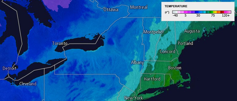
The strong southerly winds will bring in very mild air on Wednesday. Highs will be in the low 60s in most of RI, E CT, and SE MA. The warm-up will not last long as the temperature will drop quickly Wednesday night when the wind shifts to the west. Look for the temperature to fall from the 50s at sunset Wednesday to the upper 20s by dawn on Thursday. Watch out for a few icy spots as standing water may freeze. The gusty wind will help to dry the pavement, and widespread black ice is not expected.
Coastal Flooding
The storm is coming during low astronomical tides. While it is likely to cause huge waves and rough surf, the beach erosion and coastal flooding will be limited because of the low astronomical tides and the 2-2.5′ storm surge not coinciding with the time of high tide. South-facing beaches are most vulnerable to minor beach erosion and splash-over flooding on Wednesday.
Extended Forecast
Thanksgiving will be dry, but blustery and cold. Afternoon temperatures will only be in the low to mid 30s, and it will feel a lot colder because of the wind. Get the full forecast here.
The weather will stay chilly and dry into the weekend. Black Friday shoppers will have to deal with temperatures in the teens to low 20s early in the morning. It will be in the low to mid 30s with plenty of afternoon sunshine. Most of the rest of the holiday weekend looks dry. It will stay mainly clear and chilly on Saturday. Sunday will be a bit milder, with more clouds, and the chance of a few rain showers late in the day.


