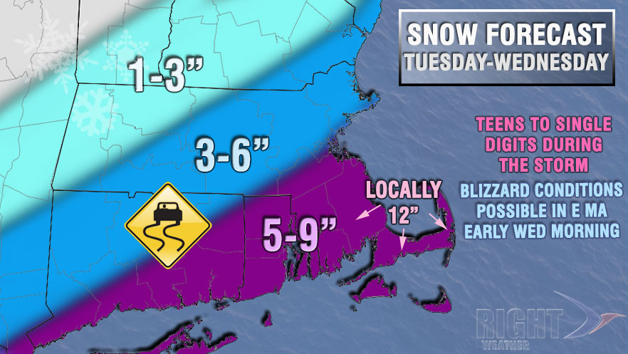
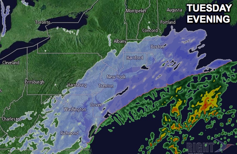
A moderate to heavy snow storm will move through Southern New England Tuesday afternoon into Wednesday morning. The storm will bring a combination of snow, wind, and bitterly cold weather as it passes southeast of Nantucket. Snow will develop from southwest to northeast through Southern New England on Tuesday. It may arrive in Connecticut by midday. Steady snow is not expected to reach RI or SE MA until mid to late afternoon. The evening commute may be impacted by the storm, especially south and west of Providence. Highs on Tuesday will only be near 20°.
- Storm Impacts Graphic
- TV Station Snow Forecast Roundup
- Right Weather Interactive Radar
- Download the FREE RightWX app for your iOS or Android device
Tuesday night looks snowy, cold and breezy to windy. The strongest winds will be near the coast, particularly on the Cape and Islands. Peak gusts should range from 25 mph inland to around 40 mph near the coast. The temperature will drop into the teens near the coast and single digits inland. The snow will be light and fluffy, and it may accumulate at a 1″ per hour rate at times.
The weather will likely still be nasty early Wednesday morning as the storm intensifies in the Atlantic Ocean. Wind-driven snow is likely through 7 am in RI, and it may linger until 9 am. It will last until late in the morning in Eastern MA. Snow totals will be fairly impressive, with many places picking up 7-9″ of powder, and some spots may get a foot.

Wednesday afternoon looks partly cloudy, blustery, and very cold. It will most likely stay in the teens, with wind chills near zero. Wednesday night looks extremely cold, with lows near zero inland, and in the single digits near the coast. It will stay frigid through Thursday. Look for mostly cloudy skies and highs in the teens. Friday does not look much warmer with highs near 20.
An Arctic cold front may trigger snow showers and squalls on Saturday. The temperature may reach the upper 20s to low 30s ahead of the front, but there is a reinforcing shot of frigid weather that will arrive as the front passes late Saturday. Sunday will be back in the 20s, and Monday could be stuck in the teens again. All the while, we’ll be on the lookout for another jet stream disturbance that could develop into a snowstorm like the one that will hit Tuesday night.


