February got off to a relatively mild start in Southern New England. Saturday featured filtered sunshine with highs in the low to mid 40s. It will stay mild on Sunday before winter returns early next week with snow likely on Monday.
- Cold, snowy January in Southern New England
- Pro Update: Action, action we want action!
- Download the RightWX app for your phone or tablet
Saturday night will be mostly cloudy and damp, with patchy fog possible. Lows will be in the mid to upper 30s. Clouds may thin a bit around midday Sunday, and highs will be in the mid to upper 40s with a light breeze. Overall, it looks like a delightful day.

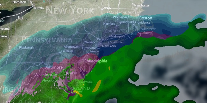
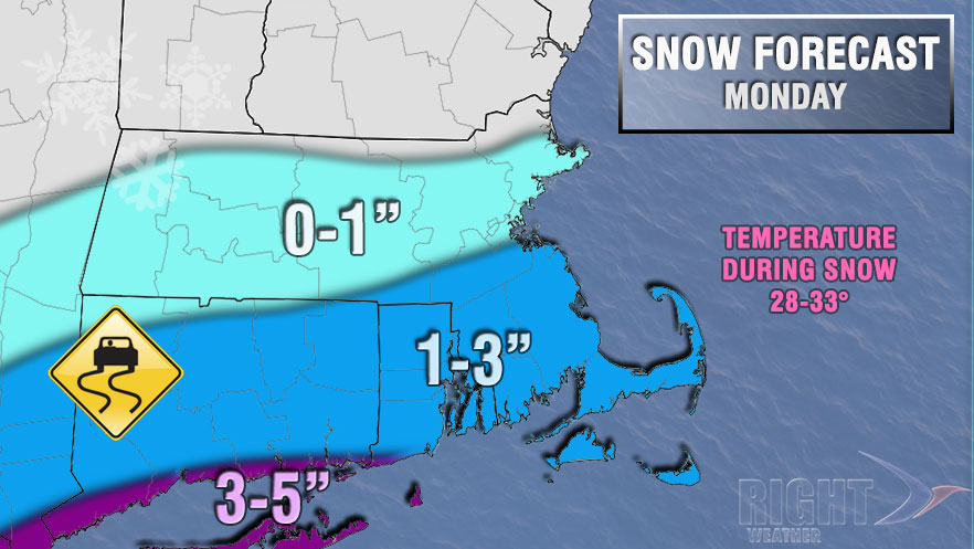
Clouds will thicken late Sunday night ahead of a storm system that will bring snow to the Mid-Atlantic and Southern New England. It will not be too cold, with lows Monday morning in the upper 20s to low 30s. Snow should develop by 9 am Monday, and it may be steady for most of the day – especially near the coast. The temperature will hover in the upper 20s to low 30s. There will be a 5-15 mph northeasterly breeze. It does not look like a major snow event, but some slick travel is possible during the day and for the evening commute. The best chance of a few inches of snow is near the coast.
The snow will end early Monday evening, and skies will clear overnight. The temperature will fall into the low to mid 20s by dawn Tuesday. It will be mostly sunny and seasonable on Tuesday. Highs will be near 40° without much of a breeze. Meanwhile, another storm will be getting organized in the Southern Plains. Clouds will thicken Tuesday evening, and snow or mixed precipitation will break out after midnight. Several inches of snow may accumulate before dawn on Wednesday. The temperature will climb into the low to mid 30s late at night. The wind will increase to 15-30 mph near the coast.
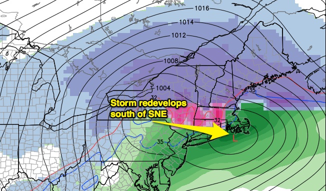
We need to watch the Tuesday night into Wednesday forecast very closely. A slight shift in the storm’s track could make the difference between a quick change to sleet and rain or a half-foot of snow followed by sleet with no rain in the Providence area. The computer models are trending to a colder, snowier scenario in Southern New England.
The storm will wind down Wednesday afternoon, and more quiet and cold weather is likely through the end of the workweek. We are already watching the potential for another storm next weekend. It is way too early to speculate about snow and/or rain, but the odds are much higher than normal that there will be some precipitation Saturday and/or Sunday.


