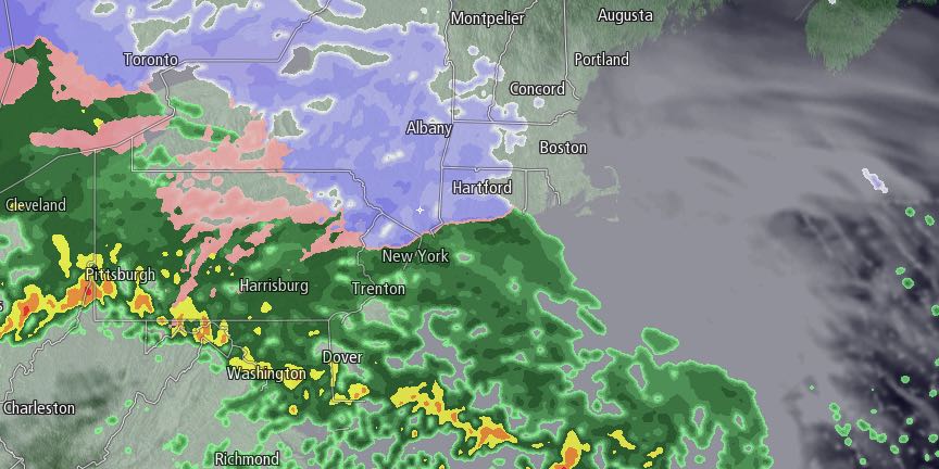
Cold air will slide into Southern New England ahead of a storm system that will bring a mix of snow, sleet, and rain Saturday night into Sunday. Most of the precipitation will be rain for Rhode Island and Southeastern Massachusetts, but it will start as snow and sleet, and a minor accumulation is possible Saturday evening. The National Weather Service has issued a Winter Weather Advisory for inland Southern New England.
The temperature will fall into the low to mid 20s by early Saturday morning under clear skies. Early morning sunshine will give way to clouds by midday, and snow will develop late in the afternoon or early in the evening. Highs will be in the low to mid 30s, and the temperature will fall to the upper 20s to low 30s when the snow begins.

There will be a quick change from snow to sleet or rain near the coast. A coating of snow is possible before the change to sleet and rain from the coast to the I-95 corridor. The timing of snow/sleet is between 5pm-8pm in that area. Further inland, the snow/sleet may hang on until around 10pm, and an inch or so of snow is possible from Providence through northwest Rhode Island. The highest elevations of NW RI may see 2″ of snow before changing to sleet and freezing rain. The temperature will gradually climb above freezing Saturday night. Any precipitation will change to rain. It may only reach the mid 30s in NW RI, but could reach the low 40s near the coast by dawn on Sunday. Rain will taper to mist and drizzle by dawn on Sunday.
Sunday morning looks mostly cloudy and damp, with temperatures steadily climbing. It will reach the upper 40s to mid 50s Sunday afternoon. Showers are possible in the morning and likely in the afternoon and evening. The wind will increase near the coast, and some 40+ mph gusts are possible. The National Weather Service has issued a Wind Advisory for part of the Southern New England coast.
Rain will end around midnight Sunday, and it will turn colder late at night. A flash-freeze is not expected as the temperature will fall to near freezing late at night, but gusty winds should help to dry the roads over a several hour span.
Monday looks partly to mostly sunny, blustery, and cold. The temperature will fall to the upper 20s by late in the day, and to the upper teens by early Tuesday morning. There will be a 15-25 mph west-northwest wind. Clouds will increase Tuesday, and light snow is possible in the afternoon and evening as an Alberta Clipper moves through the Northeast. Given the cold conditions, some accumulation is possible. It will get even colder late next week. On Thursday, the temperature may not get out of the teens, and the wind chill may stay below zero!


